Multi-week planner (8-28 days)

The Tropical Hazards map shows the passing MJO to Australias north generating rainfall across the Maritime Continent, with no influence on tropical mainland Australia during the next fortnight. Apart from warmer SSTs, it’s difficult once again to see supporting fundamentals for the BOMs extremely bullish wet July forecast (bottom chart), as the SAM also retreats towards neutral. NSW look to be the most likely area to receive wetter than normal falls this month. Check your median totals for July, as northern regions favour this category. With the exception of the NT and Ord, temperatures will likely remain normal also.

Multiweek models.jpg

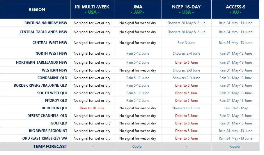
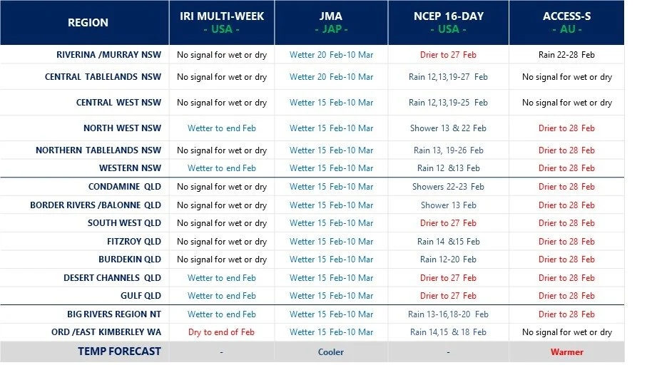
Model commentary: A quick look at the bookmaker's selections from a fortnight ago shows the US colt, NCEP first past the winning post with pre-race tactics and sticking to the rails over the distance paying dividends. The JMA also showed similar national pride with a stellar gallop on a wet track, true to form. The media hype around the ACCESS-S gelding showed glimpses of form with punters now a little more confident in the mount after recent surgery. Normally solid performing US mare IRI was more cautious before the race and sat mid-field throughout and failed to fire in the straight.

Go to 10-day Forecast XL for a full summary of all ‘weather models’ as rain events draw closer for your area: https://meteologix.com/au

BOM.jpg

Multi-week planner (8-28 days)

De Ja Vu in some sense this fortnight - the anticipation of warmer waters around Australias perimeter and increased cloud cover has some models excited by the prospects for rain over the next 4 weeks. A few more fundamentals favouring wet this time around, coming from our oceans (Modoki & IOD), however, the SOI is still not responding, sitting at zero. The IRI model is still not interested in rainfall over the analysis period anywhere in Australia. NSW and CQ look to be the main areas of favour for the remaining 3 models assessed. Cooler conditions remain until mid-July through all areas, except the tropical north.

Multiweek models.jpg

Model commentary: Stewards from the channel country and CQ were seen grinning as stallion ACCESS-S came back from vet surgery 2 stone lighter, following erratic performances in recent weeks. However, even as a gelding, this equine continues to show exuberance out of the blocks and punters are still optimistic fortunes will change perhaps now and better form approaching. JMA has crept up on the rails and the mount seems to taking the whip with a long handle this campaign. NCEP is showing a burst of speed at certain intervals along the journey, but prefers NSW and eastern Qld tracks this month.

Go to 10-day Forecast XL for a full summary of all ‘weather models’ as rain events draw closer for your area: https://meteologix.com/au

Multi-week planner (8-28 days)

The latest global cloud (OLR) predictions show heavy cloud crossing the Australian continent from 16-22 June - which seems to have the BOMs access model very excited for June (bottom figure). However, none of the other models are having a bar of it. There is no strong tropical influences or other active remote drivers behind the increased cloud cover bringing moisture, so caution required on this bullish wet forecast currently making air waves. The best chance for rainfall seems to be during weeks 2-3 of June, but no big amounts predicted, and more in line with median totals for the month.

Model commentary: Another day at the track with bookmakers salivating at the erratic form shown in the field of runners to date. The mid-field cluster seems to be centred around the IRI and JMA models playing it safe on the rails over the distance. The sprinter over the mile, NCEP, is still showing little excitement and reason to be popping corks through the latest campaign. The main talk in the betting ring is the poor form of stallion ACCESS-S, which could well come back as a gelding next week unless it can show the punters why they should remain loyal and optimistic.

Go to 10-day Forecast XL for a full summary of all ‘weather models’ as rain events draw closer for your area: https://meteologix.com/au

BOM June.jpg

Multi-week planner (8-28 days)

Every now and then we are reminded why this ensemble is useful for multi-week planning with a cross-section survey of models. The latest BOM multi-week guidance would suggest a flood for central Australia (see map added below), however, other international models have taken a very different view. For those still harvesting/picking summer crop or weaning calves etc., it looks like more of the same: fine weather until the 1st week in June when a weak change is developing. The foreseeable event early in June is tending to favour N NSW and S Qld areas, making this event pretty tricky to predict, as models don’t do easterly influences that well. The BOMs ACCESS S model has shown us that it gets way too excited by the Indian Ocean or MJO wet signals and this looks like one of those occasions.

Multiweek models.jpg

Model commentary: A fair spread on the field this week with the IRI and JMA sitting midfield and jockeys content to sit on the rails and not set the pace over the distance. On the other hand, the stewards look set to investigate ACCESS-S after streaking to the front in a show of exuberance, only to then shy at a pink dress in the crowd near the winning post and spear the jockey. NCEP is more comfortable at the tail of the field, more cautious than most, although has good form nonetheless over the shorter distance.

Go to 10-day Forecast XL for a full summary of all ‘weather models’ as rain events draw closer for your area: https://meteologix.com/au

BOMs outlook.jpg

Multi-week planner (8-28 days)

The main feature of todays multi-week planner is the stark contrast in outputs between global models. After the refresh this morning it’s almost as if the IRI model has seen the MJO fading as it hits the Australian region and is calling for a dry month of May. This dry prediction is at odds with the BOMS ACCESS-S model which looks like it has factored in the additional convection and cloud approaching from week 3 onwards (see MJO commentary, bottom chart) and is more confident of precipitation in line with “weather” models. Experience says longer-term models have poor skill picking up systems from an easterly direction, so this will be an interesting finish to May. The ECMWF 9-day model is bullish for a wet mid-May for central-eastern areas.

Multiweek models.jpg

Model commentary: The horses have jumped out of the barriers and gone in all directions this week! IRI has turned and run towards the winning post anti-clockwise after a wet forecast last fortnight. The BOM has pinned its ears back and commenced the next 3-4 weeks with a wet purpose, although has a bad habit of its jockey falling off in the home straight. The JMA is quite content to sit mid-field with cover, unwilling to take a chance either way. NCEP has shown some hope for S Qld areas keeping the punters well-lubricated in the bar on the bend towards the home straight.

Go to 10-day Forecast XL for a full summary of all ‘weather models’ as rain events draw closer for your area: https://meteologix.com/au

Multi-week planner (8-28 days)

Apart from the NSW coast and adjacent ranges, the outlook for much of Queensland and NSW looks drier than normal out to week 3 in May. With a good correlation of the MJO in Phases 4-5 leading to rain this time of year, it will be interesting to see if the current strong pulse of moist air in Phases 8 and 1 progress towards Australia in late May.

Multiweek models.jpg
horse-race-silhouette-3.png

Model commentary: IRI model sitting on the fence and not really excited by anything in the foreseeable future and is still the form equine this calendar year. The JMA got excited by a change at the start of May two weeks ago which has now disappeared and has gone an each-way bet by showing nothing wet or dry through May. The 16-day outlook showing small totals in isolated pockets but nothing much north of 10mm. ACCESS-S is generally in doomsday mode and continues to be further out, but this horse has been struggling to beat the ambulance home. It is also bearish on a favourable IOD development, at odds with other global models.

Go to 10-day Forecast XL for a full summary of all ‘weather models’ as rain events draw closer for your area: https://meteologix.com/au

Multi-week planner (8-28 days)

The outlook for much of Queensland and NSW looks drier than normal out to the first week in May. Knowing, of course, April (with August) is one of the driest months in the calendar across much of eastern Australia. A sneak peek at the ACCESS-S model shows a dry signal for winter, somewhat of a u-turn on previous forecasts. We will investigate this, and other international model guidance in more detail on our long-range outlook when seasonal models and ocean forecasts refresh shortly.

Multiweek models.jpg
horse-race-silhouette-3.png

Model commentary: IRI model is staying firm on a dry 3 weeks now out to 7 May. In hindsight, this has been a form horse through 2021. The JMA is showing a broad change for NSW and Qld at the end of April, but it’s difficult to see which climate factors are driving that, with the MJO miles away. Nothing showing on the 16-day outlook anywhere except for Ayr in FN Qld. ACCESS-S is sitting on the fence for the next four weeks, although favouring doom and gloom for winter is worth keeping an eye on when we survey other models and climate drivers shortly.

Go to 10-day Forecast XL for a full summary of all ‘weather models’ as rain events draw closer for your area: https://meteologix.com/au

Multi-week planner (8-28 days)

The outlook for much of Queensland and NSW looks drier than normal, knowing that “normal” for April is generally one of the drier months of the year for inland areas anyway. The passing MJO looks like it may only affect the Gulf and top end, although that could change in the 2nd half of April. No high temperatures showing through April either, so mild conditions prevailing throughout.

Multiweek models.jpg
horse-race-silhouette-3.png

Model commentary: IRI model is calling for a dry 3 weeks of April, except for the Gulf. This model rarely shows a signal either way and often sits on the fence, but not this time. Both the JMA and BOM are showing mainly tropical areas to benefit from the passing MJO, although the BOMs ACCESS-S model has quite an emphatic “dry” signal for NSW out to 19 April. JMA is basically sitting on the fence for NSW and S Qld rainfall. Keep an eye on the Meteologix 10 day Forecast XL for a full summary of all ‘weather models’ as rain events draw closer for your area: https://meteologix.com/au

Multi-week planner (8-28 days)

A few positive factors at play this month: broadscale low air pressure camped over Australia (see climate in brief) set to continue, waters warming up off eastern Australia, plus - moist air streaming down from NW Australia adding to the supply of already moist air. All of these results in a very unusual alignment of wetter-than-normal conditions for the next 4 weeks.

Multiweek models.jpg
horse-race-silhouette-3.png

Model commentary: IRI model has a wet tone so that in itself is an achievement. It hasn’t been excited by anything much since the December rain. It is favouring more rain across NSW than Qld, whereas the BOM model is more aligned with the 9-15 day ‘weather’ models showing Qld as the main beneficiary of decent 100-200mm+ totals. JMA, who has been the form horse of the campaign, favours rain events throughout the next 4 weeks in a general sense across the eastern half of Australia. The ACCESS-S model did a very poor job over Qld this summer, so let’s hope the current “80% chance” for rain over most of that state is not a poison chalice. Keep an eye on the Meteologix 10 day Forecast XL for a full summary of all ‘weather models’ as events draw closer for your area: https://meteologix.com/au

Multi-week planner (8-28 days)

As we move into March, a much drier month than February, most of the influence looks centred around the coast and ranges in NSW and Qld. A drier signal creeping into inland Qld and southern NSW areas. Its worth revisiting the climateapp.net.au to check on your long-term March rainfall totals to better gauge your location risk.

Multiweek models.jpg
horse-race-silhouette-3.png

Model commentary: IRI model is back to its bland, doomsday best and is showing no excitement for rain in the coming 4 weeks. JMA, who has been the form horse of the summer, favours the coast and ranges, however, no dry signal with the exception of the far north. NCEP showing activity for the coast and ranges in the coming week, consistent with the 9-day ECMWF loop. The ACCESS-S dry February forecast from a fortnight ago was the kiss-of-death some areas needed, with up to 100mm falling across NSW this week. Keep an eye on the Meteologix 10 day Forecast XL for a full summary of all ‘weather models’ as events draw closer for your area: https://meteologix.com/au

Multi-week planner (8-28 days)

The remainder of February is certainly mixed across the forecast area. With the SAM in wet phase, areas in NSW appears more likely to cash in on tropical moisture than many Qld and tropical areas. The MJO amplitude is giving us very little direction, with the broad-scale La Nina circulation keeping cloudiness in the tropics and cooler temps across our continent in the next 3 weeks or so.

Multiweek models.jpg
horse-race-silhouette-3.png

Model commentary: Looking across the suite of guidance, I can’t remember the last time multi-week models have been showing polar opposites for wet and dry. The US NCEP MJO technical report issued this week, predicts cloudiness and tropical moisture circulation to continue in northern Australia out to 8 March, yet a distinct dry signal is showing from the BOMs ACCESS model along with very little excitement from the NCEP 16-day outlook. However, the JMA guidance has low air pressure and rain camped in our region in the coming three weeks, which has generally been the consistent with prior JMA forecasts, bringing storm rain events on a weekly basis. Keep an eye on the Meteologix 10 day Forecast XL for a full summary of all ‘weather models’ as events draw closer for your area: https://meteologix.com/au

Multi-week planner (8-28 days)

Multiweek models.jpg

A very bland looking February showing in this weeks analysis. With the MJO bypassing the NE Australian region and now out in the western Pacific, there is little guidance from the climate as to the next decent 100mm rain event. With some optimism coming from the shorter-term weather models in the coming week, on the back of a spike in the SAM - the remainder of February shows many regions being at the mercy of random storm events, as we keep an eye out for the return of the MJO. Temperatures should continue to remain mild consistent with a La Niña summer.

horse-race-silhouette-3.png

Model commentary: The IRI multi-week model is preaching dry for the north, and back to vanilla flavour for much of the forecast area through to the end of Feb. The JMA is fence-sitting as well for the whole of Feb, with all the convection and rainfall activity way out in the western Pacific ocean. The 16-day NCEP model is most optimistic in the north and eastern ranges and certainly not showing the same exuberance as the 9-day ECMWF loop in this edition. The BOM ACCESS-S model is showing dry/neutral conditions for many areas, consistent with the fortnight-ago analysis which has so far turned out to be pretty accurate. Keep an eye on the Meteologix 10 day Forecast XL for a full summary of all ‘weather models’ as events draw closer for your area: https://meteologix.com/au

Multi-week model analysis (8-28 days)

Multiweek models.jpg

In the coming weeks, all the action looks to be in the FN Qld tropics and the NW Australian coastline, the latter off the back of warming SSTs and a weak MJO approaching. With the SAM dipping back towards neutral, there is nothing to suggest decent rainfall totals until at least the first week in February for most areas. Temperatures should continue to remain mild consistent with a La Niña summer. Overall, the climate is giving us little direction, while we wait in some sort of holding pattern for something to change.

horse-race-silhouette-3.png

Model commentary: The IRI multi-week model is back to its cautious best, showing rain for some areas in the tropics and a neutral flavour throughout until 12 Feb. The JMA has done a u-turn on rain for the end of Jan, with a more general rain event predicted for eastern Australia 1st half of Feb. The 16-day NCEP model is only showing patchy rain events and storm rain for most areas. The BOM ACCESS-S model has come off its high from wet-wet-wet to favour northern areas over the coming weeks and drier conditions for NSW and inland Qld areas. Keep an eye on the Meteologix 10 day Forecast XL for a full summary of all ‘weather models’ as events draw closer for your area: https://meteologix.com/au

Multi-week model analysis (8-28 days)

Multiweek models.jpg

Some spectacular colours coming through on the weather models to start 2021. However, when we move further into January the models seem to be picking up on cooling waters in the Coral Sea and again in Australia’s north. After January week 1, some caution for Qld areas, with the exception of FN Qld that cool and dry weather might persist through January. On the other hand, the activity seems to favour NSW areas, with cool, moist air continuing to feed into that state for much of the next 1-4 week period.

horse-race-silhouette-3.png

Model commentary: The IRI is certainly more optimistic for NSW in January and bearish for Kununurra and the NT Big Rivers through the next 4 weeks. The JMA is again aligned for rain across NSW and a much weaker rainfall signal for a general event in the 2nd half of January which is not overly convincing. Some small to moderate totals showing on the 16-day NCEP models, although this favour the ranges and FN Qld tropics. The BOM ACCESS-S model is picking up where it left off in 2020, with rose coloured glasses for all areas in January. I’m not sure why I bother with it, but those results need to be taken with a grain (or tablespoon) of salt. Keep an eye on the Meteologix 10 day Forecast XL for a full summary of all ‘weather models’ as events draw closer for your area: https://meteologix.com/au

Multi-week model analysis (8-28 days)

Multiweek models.png

The broad-scale pattern has finally aligned to some degree, with cooler moist air favoured to camp in the Australian region for possibly the next three to four weeks. The guidance suggests impacts and moisture receding into January, although this will largely be determined by the next move of the MJO - which is currently not acting to script. One concern for regional Qld areas is the 7-day SST anomaly showing a cooling of waters in the Coral Sea again, reducing moisture availability - at odds with the La Niña signal.

horse-race-silhouette-3.png

Model commentary: scrolling through the various weekly forecast intervals, the peak opportunity for rainfall appears to be through until around the 28 December. The JMA model is bullish wet for a month, albeit tapering off in January. The IRI model seems to be picking up on the cooling Coral Sea and is less enthusiastic about January. ACCESS-S continues unabated for a wet finish to December, so nothing has changed with it. The 16-day NCEP has small sporadic falls showing in the majority of areas, much more cautious even than the 9-day ECMWF loop. Keep an eye on the Meteologix 10 day Forecast XL for a full summary of all ‘weather models’ as events draw closer for your area: https://meteologix.com/au

Latest research - tracing the origins of moisture for precipitation

Mean moisture contribution to Australian precipitation in each season, with mean climatological low-level wind vectors.

Mean moisture contribution to Australian precipitation in each season, with mean climatological low-level wind vectors.

A team of Australian climate researchers recently investigated the origin of moisture for regional precipitation and the relative importance of local versus remote processes. Where does our moisture leading to rain come from?

Knowing the long-term average regional source of moisture provides insight into the drivers of precipitation during anomalously dry or wet periods. In the case of drought, for example, identifying the long-term average source regions can help reveal whether the low precipitation was due to a reduction in source evaporation, anomalous atmospheric circulation or a lack of local precipitation generating mechanisms.

Key findings of the study;

  • In summer, moisture for the Australian continent generally was primarily sourced from Australia’s Maritime Continent (waters around Philippines/Indonesia/Papua New Guinea)

  • Summer precipitation in the Murray Darling Basin (MBD) was primarily sourced from the Tasman Sea, Southern Ocean and land within the basin itself.

  • The MBD recycled more moisture from land sources for precipitation than any other eastern basin, with a maximum of 9.2% across the year.

  • The Australian continent receives a minimum of 77% of moisture from marine sources in summer and a maximum of 89% in winter, with the remainder recycled from land sources.

  • North-West Cloud Bands relating to the Indian Ocean Dipole interact with moisture from condensed moist air from the Tasman Sea to deliver precipitation to the MDB during spring.

What does all of this mean?

Coming into summer season, the distribution of warm waters around our perimeter does impact rainfall, although atmospheric processes involved to deliver that moisture is a whole other story!

We hope the land-sea interaction is captured in General Circulation Models, although it’s worthy of periodical monitoring the Sea Surface Temperatures in those areas identified by researchers and compare with other similar years.

Paper: Holgate, C.M., Evans, J.P., Van Dijk, A.I.J.M., Pitman, A.J. and Di Virgilio G. Australian Precipitation Recycling and Evaporative Source Regions (2020) Journal of Climate. https://doi.org/10.1175/JCLI-D-19-0926.s1

Multi-week model analysis (8-28 days)

Multiweek models.png

A signal coming through from the multi-week models for a general event around 4-14 December. With the MJO currently inactive, models seem to suggest the current high-pressure acting as an umbrella across eastern Australia will abate and moisture from the NW and NE can penetrate inland areas during the first half of December. Despite many areas will register low rainfall totals for November, big-picture drivers remain reasonably bullish (particularly for Southern NSW and NE QLD).

horse-race-silhouette-3.png

Model commentary: a surprise this morning to see the typically doomsday IRI model showing general moisture for the first half of December! The interesting feature of the JMA wet forecast was the easterly systems developing along the coast and ranges of NSW, which we’ve not seen since the Autumn. The 16-day NCEP is more of a ‘weather’ model and it was not too excited about anything much except rain in the Ord and Katherine areas. The BOMs ACCESS model has been off with the pixies since May, but now in-line with the other two multi-week models showing a wet first half of December, the next fortnight or so will be interesting to see how this pans out. Keep an eye on the Meteologix 10 day Forecast XL for a full summary of all ‘weather models’ as events draw closer for your area: https://meteologix.com/au

Multi-week model survey (8-28 days)

Multiweek models.png

A fair scatter on model outputs for the rest of November. With very little activity in the tropics predicted, its difficult to see any big totals changing management decisions in the near future. Some smaller rain events showing for the Fitzroy Valley and NSW Great Dividing Ranges thanks to a positive SAM. The climatic situation is still building favourably, with the Coral Sea warming up and the La Niña strengthening, but we may have to wait for an active MJO for a decent rain event.

horse-race-silhouette-3.png

Model commentary: the rather cautious IRI model is not keen on November rain at all. In contrast, the ACCESS-S model suggests we should load Noah’s ark, but those in the summer cropping zone have seen this hype all before. NCEP has a bit of double-digit rain activity in places, but low totals are unlikely to change much this time of year even if they do eventuate. Keep an eye on the Meteologix 10 day Forecast XL as predicted events draw closer for your area: https://meteologix.com/au

Multi-week model survey (8-28 days)

Multiweek models.png

A busy 2-3 weeks ahead for most areas with southern and eastern regions set to capture more of the moisture during the current MJO event, which is currently active over Australia in phase 5-6. When the MJO moves into the Western Pacific in November, gaps appear with fine weather returning for grain harvest in NSW and S Qld.

horse-race-silhouette-3.png

Model form: the rather cautious IRI model is more bullish for NSW and showing a dry signal for the tropics in the coming weeks. The JMA is optimistic for Qld earlier in the month and NSW later in November. The BOMs ACCESS S and ECMWF seem to have the rose coloured glasses on throughout the next three weeks and should be taken with a grain of salt. Keep an eye on the Meteologix 10 day Forecast XL as events draw closer for your area: https://meteologix.com/au

Multi-week model survey (8-28 days)

Multiweek models.jpg

The next genuine chance for rain appears to be in the eastern half of NSW mid-October with northern areas coming online at the end of October through to early November. The Niño 4 SST region has finally warmed up. This index has quite a strong correlation with rain in CQ and Gulf areas in November, so it’s plausible to expect November will be more favourable than October.

horse-race-silhouette-3.png

Model form: the BOM multi-week model continues the ‘blue kiss of death’ with over-exuberant wet forecasts. Since May if this model were remotely close Keepit and Copeton Dams would be overflowing. Seasonal and multi-week models struggle with systems originating in the Tasman Sea and assume a simplistic east-west moisture airflow. The NCEP/GFS continues to jump around and is showing a colourful system with some strength eventuating across NSW mid-Oct. The IRI model is normally super-cautious and rain across NSW this month adds to confidence levels. NT and Ord cropping zones will have to wait for the end of the month, as the air pressure at Darwin has finally moved below zero.