

Multi-week planner (8-28 days)
/The remainder of February is certainly mixed across the forecast area. With the SAM in wet phase, areas in NSW appears more likely to cash in on tropical moisture than many Qld and tropical areas. The MJO amplitude is giving us very little direction, with the broad-scale La Nina circulation keeping cloudiness in the tropics and cooler temps across our continent in the next 3 weeks or so.
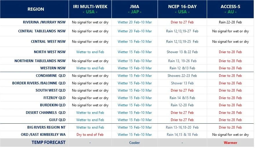

Model commentary: Looking across the suite of guidance, I can’t remember the last time multi-week models have been showing polar opposites for wet and dry. The US NCEP MJO technical report issued this week, predicts cloudiness and tropical moisture circulation to continue in northern Australia out to 8 March, yet a distinct dry signal is showing from the BOMs ACCESS model along with very little excitement from the NCEP 16-day outlook. However, the JMA guidance has low air pressure and rain camped in our region in the coming three weeks, which has generally been the consistent with prior JMA forecasts, bringing storm rain events on a weekly basis. Keep an eye on the Meteologix 10 day Forecast XL for a full summary of all ‘weather models’ as events draw closer for your area: https://meteologix.com/au