Monitoring the MJO this summer

The chart below shows a weak pulse of the MJO active in Phase 5 in the Coral Sea region. Models are anticipating the MJO to run out of steam and go back into its shell. It is essentially buried among the broad-scale La Nina pattern still at play, making it difficult to track.

The Madden – Julian Oscillation (MJO) is a tropical disturbance that moves eastward around the global tropics every 30-60 days and has proven to influence rainfall and temperature conditions. The strength of the MJO may increase or decrease as it progresses eastwards, affecting the level of convection and influence on both precipitation and temperature. The diagram below is used by scientists to track the path of the MJO showing predicted dates through various phases (see December MJO explainer). A short YouTube cartoon explaining the MJO can be found here

Monitoring soil moisture this winter copping season

Winter cropping zones have been largely replenished with the exception of SE Queensland. This may improve in the next few days as well.

The combination of subsoil moisture and a favourable seasonal outlook for 2021 (see last weeks long-range outlook) is destined to have ramifications for cropping input prices and equally, commodity prices in the longer-term.

Rootzone soil moisture 25 February

root zone moisture.jpg

2021 Autumn seasonal outlook

Bullish. That sums up the next three months for most areas. Warm waters from the La Nina appear slow to decay. Waters that have been cool in the Coral Sea are warming up. The strongest signals seem to be through central-eastern Australia, with cool/average temps across the continent.

The combined 5x North American models (bottom RHS) seem to be anticipating moisture from NW Australia to stream down into SE Aust. Whereas the BOM (top left) and combined 5x European model (top right) is favouring Queensland and NSW areas in the coming months.

autumn 2.jpg

Holman Aspect Wi-Fi weather station - product review

Holeman box.png

Tried & tested

by Richard Beattie, “Carossa” Moree, NSW

A quick pre-Christmas visit to Bunnings with the kids resulted in a cost-effective purchase that ticks the boxes.

Three months into the purchase and Richard has found that the Holman weather station ticks most of the boxes. It tracks; wind speed & direction, temperature, rainfall, air pressure, humidity and UV.

Instead of a screen, you use your phone and the Weather Underground app or website. Richard has found this website to be quite a user friendly and relatively stable.

This model (without the screen) was around $200. Bunnings is now listing the model with the screen Holman Aspect Wi-fi Analyst for $229

Wundermap.png

Weather underground = www.wunderground.com

On this US website, settings can be changed to metric. Data can be viewed for your own station as well as a range of public and private weather stations.

Accuracy.

Richard has generally found the data to be comparable, but rainfall measurements under 5mm sometimes seem to under register.

Holeman aspect.png

If you want to save your weather stations historical data this might not be the option for you.

There is no simple way to download or save historical data from wunderground.com. I did find some sort of code on the internet that was supposed to save a file to my computer - but those instructions were beyond me.

Another downfall, if the internet connection is lost, the data for that period is not logged. A power outage, while Richard was off-farm (and a modem that didn’t power back on), meant the on-farm rainfall couldn’t be viewed or recorded. The times you are away are often the times you most want or need the data.

Holeman installed.png

Simple set up.

The weather station was simple to install - just a post in the ground within 150m of the WiFi receiver. This enables the reading, such as wind to be out in the open, away from trees and the house perimeter.

The verdict.

A very cost-effective weather station (compared to other popular brands that can be up to $3000). A good choice, if you are happy to view the data most of the time and saving the historical data, isn’t a priority. Limited to areas where WiFi is available also.

Data graphs on wunderground.com

Data graphs on wunderground.com

 
Holman station snapshot on wunderground.com

Holman station snapshot on wunderground.com


Want to share your experience with a weather station or app?

Email us at: farmerforecast@agecon.com.au

2021 Long-range Outlook

  • The latest IRI Enso outlook has improved again since January (RHS). Still not a strong signal for La Niña to meet thresholds, but none-the-less El Niño still a long-shot for 2021 at this stage.

  • ENSO Modoki, one of the few autumn drivers statistically significant during winter crop planting, although weakening, is showing a continuation of the current wet signal. This is encouraging for much of the central-eastern Australian cropping belt. We need to keep an eye on this.

  • The Indian Ocean Dipole outlook is inherently erratic this time of year. The current JAMSTEC IOD outlook is not offering much and looks to be quite close to zero in the neutral range.

    With the national AWAP soil moisture map (from last Friday) looking replenished and with this sort of outlook, Australian grain markets will probably start to sense supply pressure at some stage if this continues.

    Charts Courtesy IRI (US)

The chart above shows higher-than-normal probabilities (blue line - red arrow) of the La Niña hanging around. In the critical spring months, the board Nino3.4 indicator shows a possible La Nina return. https://iri.columbia.edu/our-expertise/climate/…

The chart above shows higher-than-normal probabilities (blue line - red arrow) of the La Niña hanging around. In the critical spring months, the board Nino3.4 indicator shows a possible La Nina return. https://iri.columbia.edu/our-expertise/climate/forecasts/enso/current/?enso_tab=enso-cpc_plume

IRI winter precip forecast (16 Feb 2021)

With 4 or 5 North American models bundled together here, one of which is NASA (which overshoots wet) one can assume the slight La Nina signal, coupled with a weak La Nina Modoki has produced the wetter outlook for winter across the eastern half of A…

With 4 or 5 North American models bundled together here, one of which is NASA (which overshoots wet) one can assume the slight La Nina signal, coupled with a weak La Nina Modoki has produced the wetter outlook for winter across the eastern half of Australia.

Forecast chart courtesy: https://iri.columbia.edu/our-expertise/climate/forecasts/seasonal-climate-forecasts/

Monitoring heat waves in the coming week

The synoptic situation is set up to trap some heat across eastern Qld coastal and adjacent areas eartly next week. Not much extreme heat elsewhere with remaining areas enjoying mild conditions.

Heatwave forecast starting Saturday 21 February through to Wednesday 24 February 2021

heat waves.jpg

About heat waves

Heatwaves are calculated using the forecast maximum and minimum temperatures over the next three days, comparing this to actual temperatures over the previous thirty days, and then comparing these same three days to the 'normal' temperatures expected for that particular location. Using this calculation takes into account people's ability to adapt to the heat. For example, the same high temperature will be felt differently by residents in Moree compared to those in Orange, who are not used to the higher range of temperatures experienced in Moree. The full forecast can be accessed here: http://www.bom.gov.au/australia/heatwave/

9-day ECMWF rainfall outlook

The European ECMWF 9-day model shows rainfall activity creeping inland off the east coast and persisting through inland FN Qld. A positive SAM is pushing moisture into NSW and a sub-tropical low is developing in the Tasman Sea also.

Looking beyond the 9-day period, the northern half of Australia appears to be going toward a drier period, before more low pressure and cloud activity returns at the end of the 1st week in March.

Tune in next week for a full analysis.

Access courtesy https://meteologix.com/au

Image loop courtesy Meteologix

Image loop courtesy Meteologix


Climate in-brief

  • The MJO is active in Phase 7 out in the Western Pacific Ocean, however unlikely to influence our climate for the remainder of February.

  • Following a wet few days in the coming weather forecast for many areas, NSW looks to be the best chance for rain for the remainder of the month.

  • The Southern Annular Mode is firmly in positive phase, which will aid in moisture circulation for storms through eastern areas of NSW and sth Qld coast in the coming fortnight

  • Very little in the way of cyclone activity in the northern tropics, with the MJO out in the western Pacific Ocean.

The chart above shows lower air pressure pretty much over the entire continent. The JMA model is predicting this to continue for the coming weeks, although thats the only model doing so.

The chart above shows lower air pressure pretty much over the entire continent. The JMA model is predicting this to continue for the coming weeks, although thats the only model doing so.

Australian daily and weekly rainfall observations

Some excellent falls in Central Qld catchments overnight - that badly needed rain. Click on the link for an updated map. http://www.bom.gov.au/australia/flood/?ref=ftr

Some excellent falls in Central Qld catchments overnight - that badly needed rain. Click on the link for an updated map. http://www.bom.gov.au/australia/flood/?ref=ftr

Weekly rain shows some fantastic falls across the tropics and parts of eastern Australia. February is the wettest month in the calendar for many agricultural areas but many still need more rain.Australian 7-day rainfall map courtesy http://www.bom.g…

Weekly rain shows some fantastic falls across the tropics and parts of eastern Australia. February is the wettest month in the calendar for many agricultural areas but many still need more rain.

Australian 7-day rainfall map courtesy http://www.bom.gov.au/climate/maps/rainfall/?variable=rainfall&map=totals&period=week&region=nat&year=2020&month=12&day=17

Multi-week planner (8-28 days)

The remainder of February is certainly mixed across the forecast area. With the SAM in wet phase, areas in NSW appears more likely to cash in on tropical moisture than many Qld and tropical areas. The MJO amplitude is giving us very little direction, with the broad-scale La Nina circulation keeping cloudiness in the tropics and cooler temps across our continent in the next 3 weeks or so.

Multiweek models.jpg
horse-race-silhouette-3.png

Model commentary: Looking across the suite of guidance, I can’t remember the last time multi-week models have been showing polar opposites for wet and dry. The US NCEP MJO technical report issued this week, predicts cloudiness and tropical moisture circulation to continue in northern Australia out to 8 March, yet a distinct dry signal is showing from the BOMs ACCESS model along with very little excitement from the NCEP 16-day outlook. However, the JMA guidance has low air pressure and rain camped in our region in the coming three weeks, which has generally been the consistent with prior JMA forecasts, bringing storm rain events on a weekly basis. Keep an eye on the Meteologix 10 day Forecast XL for a full summary of all ‘weather models’ as events draw closer for your area: https://meteologix.com/au

Monitoring the SAM

The SAM is fairly stable in positive (wet) phase at the moment and set to continue. A stronger positive surge of the SAM would certainly boost confidence for rainfall prospects in eastern areas of S Qld and NSW in the coming weeks. Its influence will be reduced once we move into March.

Antarctic Oscillation or SAM values (12 Feb)

Recent research by Hendon et al, (2014) at the Centre for Australian Weather and Climate Research found the Southern Annular Mode to be the leading mode of circulation variability through parts of inland eastern Australia where cotton is grown; particularly in the spring planting period.
 
A positive SAM has been proven to increase moisture supply into fronts and troughs forming in eastern Australia. The chart provided by Climate Prediction Center (US) shows the most recent observations of the SAM or (AAO). 

A negative SAM traditionally leads to a dry westerly circulation pattern through eastern Australian cropping areas.
 
BOM researchers Lim and Hendon (2013) found the SAM has the strongest connection with El-Niño Southern Oscillation in October and November – whereby the SAM is influenced most by El Niño or La Niña conditions.

Growers and advisors are encouraged to monitor the phases of the SAM together with seasonal forecasting, multi-week and short term weather models during planting. A short cartoon explaining the SAM can be found HERE

Monitoring the MJO this summer

Much of our moisture originates from the tropics this time of year. The chart below shows the MJO active in Phase 7 out in the Western Pacific Ocean. Models are anticipating the MJO to run out of steam and go back into its shell for the remainder of February and have little or no influence on our climate.

The Madden – Julian Oscillation (MJO) is a tropical disturbance that moves eastward around the global tropics every 30-60 days and has proven to influence rainfall and temperature conditions. The strength of the MJO may increase or decrease as it progresses eastwards, affecting the level of convection and influence on both precipitation and temperature. The diagram below is used by scientists to track the path of the MJO showing predicted dates through various phases (see December MJO explainer). A short YouTube cartoon explaining the MJO can be found here

9-day ECMWF rainfall outlook

The European ECMWF 9-day model shows a kaleidoscope of colour, with rainfall predicted through northern and eastern Australia in the coming week and a half. A positive SAM is pushing moisture into NSW and rain is also showing in the desert channels and other regions through the interior. However, models are divided, so its there is real value in checking the Meteologix model survey to see how the predicted amounts differ, to better evaluate your chances of rain through this period. Access courtesy https://meteologix.com/au

Image loop courtesy Meteologix

Image loop courtesy Meteologix


9-day ECMWF rainfall outlook

The European ECMWF 9-day model shows good falls in the SE as well as inland tropical areas at lower latitudes. A quick peek at the refreshed multi-week models this morning shows non-consensus for the remainder of February, with the JMA calling for wet conditions continuing, while the BOM and IRI (US) are sitting on the fence for neither wet nor dry. Probably safe to assume storms will be around and temperatures will continue to be milder than normal. Access courtesy https://meteologix.com/au

Image loop courtesy Meteologix

Image loop courtesy Meteologix


Meet the researcher - Dr Ben Henley

Long-term wet-dry phases are largely driven by the distribution of warm water across certain regions of the Pacific Ocean. This phenomenon is referred to as the Inter-decadal Pacific Oscillation (IPO) or Pacific Decadal Oscillation (PDO). A broad understanding of these multi-year cycles can help create context and reflect on the timeliness of farm investment, leasing, irrigation water availability, machinery purchases or hiring of personnel. One of Australia’s leading climate researchers in this complex area is Dr Ben Henley of Monash University, Melbourne. His research focuses on climate variability, drought risk, and hydrological impacts using multi-proxy palaeoclimate records observed data and climate model simulations.

Ben-285dhps.jpg

Dr Ben Henley

Climate researcher

What inspired you to become a climate researcher and at what age was this?

As a small boy, I was fascinated by the natural world. I grew up at the top of a hill in Charlestown, near Newcastle in NSW, surrounded by plants, animals, bush, lake, coast and big skies. From a young age, I watched the weather, the changing seasons and the coal ships from that hill. I came to harbour a sense that we humans can find better ways to live – in support of both human and natural systems – and that this could be achieved through engineering and science. So, I studied Civil and Environmental Engineering. I later combined my mutual love of music and science by studying Acoustics, in Sweden actually. I gathered skills in physics and maths which would end up having some surprising uses in areas of climate and hydrology. I came to understand the scale of the climate change problem after returning from overseas in my early 20s. I read widely on the topic and decided that I simply had to do something to contribute to solving the problem. From then I have been trying to better understand climate change and variability, water resources and how we can best prepare for an uncertain and challenging future. 

 Do you have any extended family or other connections with farming or agriculture?

I have extended family out near Coonabarabran in NSW, and have great memories visiting their farms as a kid, playing with emu chicks, calves and finding yabbies. My family has always grown our own fruit and vegetables, and my Dad is a passionate gardener of native plants. I hope one day to have a small hobby farm of my own. With a good scientific sense of the variability of the Australian climate, and having such a strong personal connection to the land, I have a deep respect for farming, and the challenges farmers face. I think that is what led me to study drought.

Ben as a youngster, was always fascinated by nature and the environment (Above) and in an interview with ABC newsreader, Ros childs, live on midday tv (RHS).

Ben as a youngster, was always fascinated by nature and the environment (Above) and in an interview with ABC newsreader, Ros childs, live on midday tv (RHS).

Screen Shot 2021-02-04 at 9.19.08 am.png

What are your favourite activities or interests away from research that helps recharge you for work mode?

Music, the outdoors, family and community have always been a huge part of my life. I started playing the piano when I was about 5. I was incredibly lucky that a world-class piano teacher, Ms Rosemary Witcomb, happened to live at the end of my street at the time, and my parents supported my music so deeply. Studying eighth grade classical piano at the same time as year twelve was not easy, but I’ve found that what you put into music, it gives back ten-fold, and at times it is what keeps me going and makes me who I am. I later picked up a couple of other instruments and regularly accompany and harmonise with my wife, who is a professional singer-songwriter, in her choirs and in the general fabric of our day. I loved soccer and cricket as a kid but tend to stick to more individual sports these days. Staying the course through the stresses of academia, like many other professions, demands regular physical and mental escapes including running, bushwalks, yoga, meditation, family, and music.   

The “tripole” index, developed by ben is now an internationally recognised method of measuring and assessing long-term cycles of wet and dry in the pacific basin, which has effects across the globe.

The “tripole” index, developed by ben is now an internationally recognised method of measuring and assessing long-term cycles of wet and dry in the pacific basin, which has effects across the globe.

What is the simplest, no-nonsense way you can explain the Interdecadal Pacific Oscillation (PDO)?

The Interdecadal Pacific Oscillation is a climate pattern in the Pacific which varies from decade to decade and affects global and regional climate on 10–40 year timescales. It is like El Niño and La Niña’s older, slower moving, uncle or auntie, I suppose. We have lots of clues as to what drives these slow changes, and how they link to other ocean basins and the El Niño system, as well as how this pattern has behaved in the past, including the impacts on Australia. But our understanding of the underlying physics and potential avenues for predictability of these decade to decade changes remains a matter for ongoing research.

Your 2015 paper with co-author Prof. David Karoly and others has been cited almost 300 times. The tripole index is now published on the NOAA (US) website. What made you curious to take on the task of developing this index for the Interdecadal Pacific Oscillation?

The paper arose from a simple recognition, by David and me I recall, that at that point there was no simple and widely-used index to track the Interdecadal Pacific Oscillation (the IPO). Because the IPO has a signature that extends well beyond the tropics, using an index of El Niño that focusses only on the tropical Pacific would not tell the full story. So, we set about developing our own index. There are of course other ways to track the IPO, which are certainly valid. I am stoked that the index has been useful to many people and that NOAA maintains and updates the index we developed. I learnt through that process, that the most widely used scientific findings are often those which build tools or datasets for others to use.   

Groups of years put together by the longpaddock show the recent 8-year dry spell, together with the wet-dry phase of the IPO. Click on the image to explore these maps.

Groups of years put together by the longpaddock show the recent 8-year dry spell, together with the wet-dry phase of the IPO. Click on the image to explore these maps.

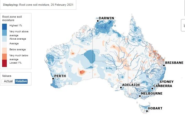
The rainfall charts produced by the longpaddock.com.au (see image to the right) are fascinating, with clearly defined wet and dry phases that seem broadly aligned with the PDO. It seems more obvious in hindsight, but what are the issues with predicting the next move of this phenomenon? 

Reliable predictions of any climate phenomenon rely on a few key things, namely i) a strong understanding of the physical climate mechanisms and the precursors to any shifts; ii) accurate climate model representations, and iii) success in the evaluation of predictions using what is called model hindcast verification. In the case of decade-to-decade changes in the climate, these are very big hurdles! The scientific community has not settled on any one single mechanism for the IPO. We have identified numerous potential drivers and past precursors to the shifts, and there are some excellent theories that need developing and testing. In short: it’s a chaotic system and we need to better observe it, understand it, and model it. I would like to see a concerted global research effort on this topic. I previously proposed a small version of such a project, but alas, my idea narrowly missed out on funding. That’s ok, I’m sure there were other great projects! I think the 10 to 20-year future timeframe is a big challenge, both scientifically, and to those on the land. What happens in the next 10–20 years is critically important for people managing water resources and agricultural systems and it would help a lot to have a clearer insight into that near-term future.

Reconstructing ENSO and other climate drivers using coral cores, tree rings and other measurements over longer-term timescales is also another keen interest area of your research. What are the standout take-home messages you can share that can help us contextualise the horrific 2019 drought and better plan for an extreme period of wet or dry?

Horrific it was. As if the drought was not enough, the intensity and scale of the fires that followed shocked us all. I worked on a paper recently with a large group of scientists led by Nerilie Abram, to put those drought and fire conditions into a longer-term context. The brief message is that we have a highly variable climate and we should expect extremes from year to year, but climate change contributed, and it will continue to throw some massive challenges at us in the coming decades. I’ve used records from corals, tree rings and ice cores to build up multi-century reconstructions of the past, which show that variability is a fundamental feature of our climate but that the rate of global temperature increase is staggering compared to past centuries. Climate change is accelerating, and we must all do all we can to mitigate it and adapt to it, implementing actions locally and adding our voices to the long-term solutions at the global scale. My advice is simple: plan for extremes and take action now. Use the best available evidence to adapt our systems to a variable and changing climate and make rapid structural changes which will contribute to global solutions. Easier said than done, but we must do it.

Click on the short YouTube Below for an explanation of what the Pacific Decadal Oscillation is, how its measured and some impacts.

 
Click on the image to access this 3-minute YouTube on the PDO courtesy UK Met Office.

Click on the image to access this 3-minute YouTube on the PDO courtesy UK Met Office.


Any questions, feedback for Ben or Farmer Forecast?

Email us at: farmerforecast@agecon.com.au

Monitoring heat waves in the coming week

Not much extreme heat to trouble the scorers in the coming week with all areas except coastal Qld enjoying mild conditions.

Heatwave forecast starting Saturday 7 February through to Wednesday 10 February 2021

Heatwave service.jpg

About heat waves

Heatwaves are calculated using the forecast maximum and minimum temperatures over the next three days, comparing this to actual temperatures over the previous thirty days, and then comparing these same three days to the 'normal' temperatures expected for that particular location. Using this calculation takes into account people's ability to adapt to the heat. For example, the same high temperature will be felt differently by residents in Moree compared to those in Orange, who are not used to the higher range of temperatures experienced in Moree. The full forecast can be accessed here: http://www.bom.gov.au/australia/heatwave/

Climate in-brief

  • After a period of inactivity, the MJO has leapfrogged the eastern Australian longitudes and reappeared NE of Australia in the Western Pacific ocean, and in doing to taking much-needed moisture with it

  • Very little on the horizon in the way of general rain forecast for most areas after the first week in February, other than random storm events

  • The Southern Annular Mode has made a resurgence into positive (wet) phase again, which will aid in moisture circulation for storms through eastern areas of NSW and Qld in the coming fortnight

  • The MJO phase will be critical in the coming fortnight as it passes through Phases 7-8, away from the Australian region, and will require close monitoring to track heat waves and the next general rain event

The chart above shows lower air pressure pretty much a mirror image of the 7-day rainfall chart below, with qld areas remaining dry over the last week.

The chart above shows lower air pressure pretty much a mirror image of the 7-day rainfall chart below, with qld areas remaining dry over the last week.

Australian daily and weekly rainfall observations

Some excellent falls in the southern half of NSW overnight, and kununurra continues its stellar January run of totals. Click on the link for an updated map. http://www.bom.gov.au/australia/flood/?ref=ftr

Some excellent falls in the southern half of NSW overnight, and kununurra continues its stellar January run of totals. Click on the link for an updated map. http://www.bom.gov.au/australia/flood/?ref=ftr

Weekly rain shows some fantastic falls across the tropics and parts of CQ desperately in need of rain. NSW has been on the skinnier end of falls in the last week.Australian 7-day rainfall map courtesy http://www.bom.gov.au/climate/maps/rainfall/?var…

Weekly rain shows some fantastic falls across the tropics and parts of CQ desperately in need of rain. NSW has been on the skinnier end of falls in the last week.

Australian 7-day rainfall map courtesy http://www.bom.gov.au/climate/maps/rainfall/?variable=rainfall&map=totals&period=week&region=nat&year=2020&month=12&day=17