10-day rainfall outlook

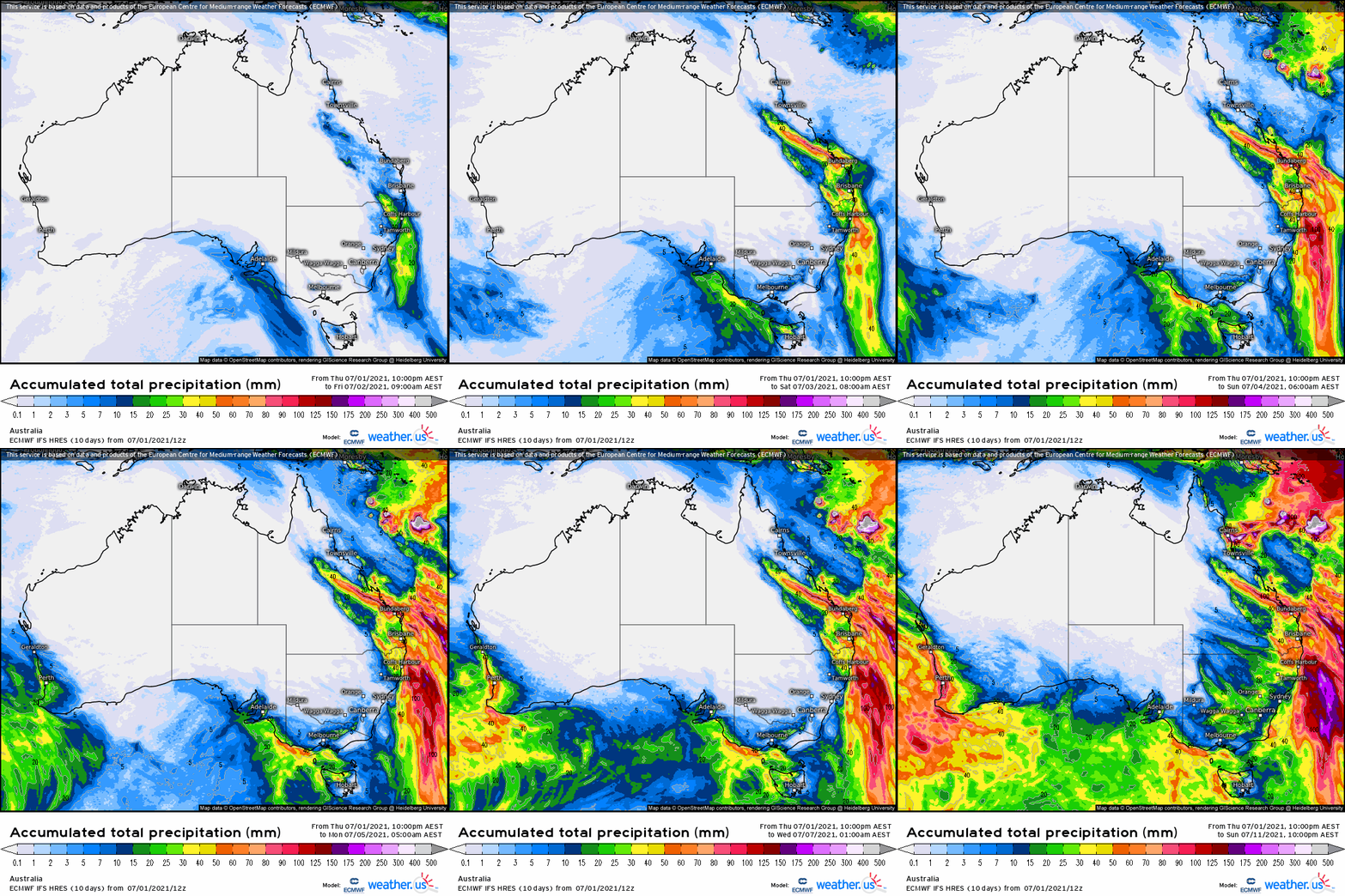
Today’s 10-day ECMWF model loop favours smaller rainfall totals in the eastern half of NSW and C Qld. A quick run around the grounds this morning and we still have a split jury on the BOMs emphatic forecast wet July. The JMA and IRI refreshed outputs have a neutral-dry-ish theme for the next 10-28 days, with some light falls for NSW. More detail in next Fridays fortnightly climate wrap-up.

Keep an eye on https://meteologix.com/au for more site-specific analysis.

Image loop courtesy Meteologix

Image loop courtesy Meteologix


10-day rainfall outlook

Today’s 10-day ECMWF model loop is favouring the eastern half of NSW and Qld as the main rainfall beneficiaries. A look at the refreshed JMA, BOM and IRI weekly predictions show a wide model spread, consistent with the last 6 weeks. The BOM is still very excited about serious wet conditions for large areas - off the back of warm oceans around Australia. Again, none of the other globals are interested in anything other than patchy rainfall events (leading to average monthly totals) in the coming weeks. Click through next Friday for a more detailed multi-week analysis.

Keep an eye on https://meteologix.com/au for more site-specific analysis.

Image loop courtesy Meteologix

Image loop courtesy Meteologix


10-day rainfall outlook

Today’s 10-day ECMWF model loop shows most of the action in NSW and a system developing across central eastern Qld areas (later in the loop) that have been missing out. Could be an interesting month with quite a range of scenarios among models for the month of June. Weather models are much better at picking up rain-bearing systems originating from the east, as multi-week and seasonal models seem to struggle to accurately simulate these smaller, intense events.

Keep an eye on https://meteologix.com/au for more site-specific analysis.

Image loop courtesy Meteologix

Image loop courtesy Meteologix


10-day rainfall outlook

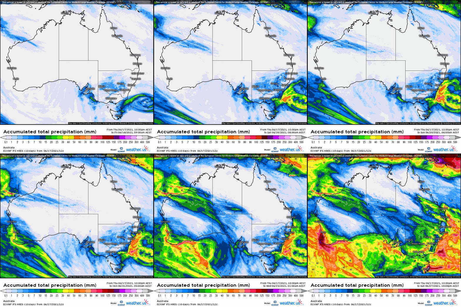
Today’s 10-day ECMWF model loop shows most of the action in the west, with some light falls in eastern states at the end of the forecast loop. A quick look at the refreshed JMA model (IRI not updated) sees this pattern continuing and moisture moving across to central Australian areas, not quite making it to NSW and Qld now until the second half of June.

Keep an eye on https://meteologix.com/au for more site-specific analysis.

Image loop courtesy Meteologix

Image loop courtesy Meteologix


10-day rainfall outlook

Today’s 10-day ECMWF model loop shows coastal systems dominating the next period. A dry outlook for most inland areas with a high-pressure ridge taking up residence. A hint of moisture creeping into the loop from the west on day 10 coinciding with the arrival of the MJO.

Keep an eye on https://meteologix.com/au for more site-specific analysis.

Image loop courtesy Meteologix

Image loop courtesy Meteologix


9-day rainfall outlook

Today’s 9-day ECMWF model loop shows a rain-bearing system developing across central eastern areas over the coming week or so. Very little to report for tropical areas, with the MJO approaching in Phases 2-3 one would expect that to be the case, with all the moisture being pulled away from the tropics towards the Indian Ocean.

Keep an eye on https://meteologix.com/au for more site-specific analysis.

Image loop courtesy Meteologix

Image loop courtesy Meteologix


9-day rainfall outlook

Today’s 9-day ECMWF model loop shows some convective moisture from the warm Ningaloo Reef region in W.A streaming across to NSW through the first week in May. Some rainfall also along the Qld coast. A quick glance at the refreshed IRI and JMA multi-week models and things are looking good with both keen on NSW and sth Qld receiving rain in the next fortnight!! More details on the May outlook next week.

Keep an eye on https://meteologix.com/au for more site-specific analysis.

Image loop courtesy Meteologix

Image loop courtesy Meteologix


9-day rainfall outlook

This morning’s 9-day ECMWF model loop shows coastal systems dominating the next period. A check around the grounds on the refreshed seasonal outlook shows a neutral/dry winter and a wetter spring when the IOD/Modoki develops. More detail next week.

Keep an eye on https://meteologix.com/au for more site-specific analysis.

Image loop courtesy Meteologix

Image loop courtesy Meteologix


9-day rainfall outlook

This morning’s 9-day ECMWF model loop shows a scud over Central Qld (that missed much of the March rainfall activity) so let’s hope those dry areas can catch up on their 2021 totals.

A sneak peek of the refreshed multi-week models shows more of the same - clear and mild temps for the remainder of April, with the exception of another rain event for C Qld mid-month. Full analysis next week.

Keep an eye on https://meteologix.com/au for more site-specific analysis.

Image loop courtesy Meteologix

Image loop courtesy Meteologix


9-15 day rainfall outlook

Two leading models this week: 9-day ECMWF and NCEP 15-day loop.

Some serious rainfall activity predicted for parts of Australia’s NW and eastern areas.

A sneak peek at the updated multi-week models just now shows the BOM model going extreme wet ‘till mid-April, JMA showing slightly above average and the IRI model much more cautious with a focus on rain events for inland NSW, Qld channel country and the Gulf for the next 3 weeks.

Updated SSTs show waters warming to Australia’s north and the Coral Sea continues to warm up, which is encouraging.

Keep an eye on https://meteologix.com/au for more site-specific analysis.

Image loop courtesy Meteologix

Image loop courtesy Meteologix

modusa_20210318_2200_animation 15day.gif

9-15 day rainfall outlook

Two leading models this week: 9-day ECMWF and NCEP 15-day loop.

Some serious activity predicted for parts of Qld previously missing out, as well as eastern NSW.

Moisture from Australia’s north-west seems to be joining up with moist air in the Coral Sea and where exactly it lands will be interesting.

A game-changing event for those who’ve been on the skinny end of a pop-gun La Nina so far this summer.

Keep an eye on https://meteologix.com/au for more site-specific analysis.

Image loop courtesy Meteologix

Image loop courtesy Meteologix

modusa_20210311_2300_animation GFS.gif

9-day ECMWF rainfall outlook

The European ECMWF weather model shows some serious rainfall activity through central-eastern Australia during the next 9-day period, as the Coral Sea finally warms up. The US NCEP model is even more bullish for bigger +100mm totals. A sneak peek at the refreshed multi-week models this morning shows NSW in the sweet spot for the remainder of March, with NW tropical moisture streaming down across the desert. More analysis next Friday.

Access courtesy https://meteologix.com/au

Image loop courtesy Meteologix

Image loop courtesy Meteologix


9-day ECMWF rainfall outlook

The European ECMWF 9-day model shows rainfall activity creeping inland off the east coast and persisting through inland FN Qld. A positive SAM is pushing moisture into NSW and a sub-tropical low is developing in the Tasman Sea also.

Looking beyond the 9-day period, the northern half of Australia appears to be going toward a drier period, before more low pressure and cloud activity returns at the end of the 1st week in March.

Tune in next week for a full analysis.

Access courtesy https://meteologix.com/au

Image loop courtesy Meteologix

Image loop courtesy Meteologix