Multi-week planner (8-28 days)

Multiweek models.jpg

A very bland looking February showing in this weeks analysis. With the MJO bypassing the NE Australian region and now out in the western Pacific, there is little guidance from the climate as to the next decent 100mm rain event. With some optimism coming from the shorter-term weather models in the coming week, on the back of a spike in the SAM - the remainder of February shows many regions being at the mercy of random storm events, as we keep an eye out for the return of the MJO. Temperatures should continue to remain mild consistent with a La Niña summer.

horse-race-silhouette-3.png

Model commentary: The IRI multi-week model is preaching dry for the north, and back to vanilla flavour for much of the forecast area through to the end of Feb. The JMA is fence-sitting as well for the whole of Feb, with all the convection and rainfall activity way out in the western Pacific ocean. The 16-day NCEP model is most optimistic in the north and eastern ranges and certainly not showing the same exuberance as the 9-day ECMWF loop in this edition. The BOM ACCESS-S model is showing dry/neutral conditions for many areas, consistent with the fortnight-ago analysis which has so far turned out to be pretty accurate. Keep an eye on the Meteologix 10 day Forecast XL for a full summary of all ‘weather models’ as events draw closer for your area: https://meteologix.com/au

Monitoring the SAM

The SAM had a brief stint in negative/neutral zone but has since recovered and is trending towards wetter phase in the next fortnight. A stronger positive surge of the SAM would certainly boost confidence for rainfall prospects in eastern areas of S Qld and NSW in the coming weeks.

Antarctic Oscillation or SAM values (29 Jan)

Recent research by Hendon et al, (2014) at the Centre for Australian Weather and Climate Research found the Southern Annular Mode to be the leading mode of circulation variability through parts of inland eastern Australia where cotton is grown; particularly in the spring planting period.
 
A positive SAM has been proven to increase moisture supply into fronts and troughs forming in eastern Australia. The chart provided by Climate Prediction Center (US) shows the most recent observations of the SAM or (AAO). 

A negative SAM traditionally leads to a dry westerly circulation pattern through eastern Australian cropping areas.
 
BOM researchers Lim and Hendon (2013) found the SAM has the strongest connection with El-Niño Southern Oscillation in October and November – whereby the SAM is influenced most by El Niño or La Niña conditions.

Growers and advisors are encouraged to monitor the phases of the SAM together with seasonal forecasting, multi-week and short term weather models during planting. A short cartoon explaining the SAM can be found HERE

Monitoring the MJO this summer

Much of our moisture originates from the tropics this time of year. The chart below shows the MJO breaking out of the circle (to active phase) into Phase 6 out in the Western Pacific Ocean. Most of the action appears to now be centred around these longitudes, to the east of Australia “ Enhanced convection is favoured to increase over the western Pacific to the west of the Date Line during the next two weeks” NCEP report 25 Jan 2021. This is not ideal for those of us looking for rain, as we may have to wait for the MJO to return on later in February to see some genuine monsoon activity on a decent scale.

The Madden – Julian Oscillation (MJO) is a tropical disturbance that moves eastward around the global tropics every 30-60 days and has proven to influence rainfall and temperature conditions. The strength of the MJO may increase or decrease as it progresses eastwards, affecting the level of convection and influence on both precipitation and temperature. The diagram below is used by scientists to track the path of the MJO showing predicted dates through various phases (see December MJO explainer). A short YouTube cartoon explaining the MJO can be found here

9-day ECMWF rainfall outlook

The European ECMWF 9-day model shows good falls in the SE as well as the same tropical areas that are already quite wet. NCEP is more conservative, although the BOMs 8-day WATL model is more encouraging. Once we are through the 1st week of Feb, then opportunities for rain look reasonably thin, so caution required.

Access courtesy https://meteologix.com/au

modez_20210128_2300_animation.gif

Tracking atmospheric water vapour (Sat-Tue)

The prediction for water vapour levels shows a concentration over north-west Australia, and surprisingly not showing up (as high levels) over SE Australia where rain is predicted for Monday-Tuesday.

The water vapor content of the atmosphere is of critical importance to nearly every facet of atmospheric science. Observing the processes that determine the water vapor content of the atmosphere is, therefore, of fundamental importance. As the earth’s surface is the source of most atmospheric water vapor, observations of vertical turbulent transport of water vapor in the planetary boundary layer have been the subject of many research projects. Evapotranspiration can vary significantly across the earth’s surface due, for example, to variability in insolation, vegetation cover, soil properties, and precipitation. Area-averaged water vapor flux measurements are necessary to get a large-scale view of surface–atmosphere interactions. 

The Extreme Forecasting Index (EFI) is an integral measure of the difference between the ensemble forecast (ENS) distribution and the model climate (M-climate) distribution. This allows the abnormality of the forecast weather situation to be assessed without defining specific (space- and time-dependant) thresholds. The EFI takes values from -1 to +1. If all the ensemble members forecast values above the M-climate maximum, EFI = +1; if they all forecast values below the M-climate minimum, EFI = -1. Experience suggests that EFI magnitudes of 0.5 - 0.8 (irrespective of sign) can be generally regarded as signifying that "unusual" weather is likely whilst magnitudes above 0.8 usually signify that "very unusual" weather is likely. Although larger EFI values indicate that an extreme event is more likely, the values do not represent probabilities as such. 

2021 Long-range Outlook

  • The latest IRI Enso outlook has improved since last month (RHS). Still not a strong signal for La Niña to meet thresholds, but none-the-less El Niño a long-shot at this stage.

  • ENSO Modoki, one of the few autumn drivers statistically significant during winter crop planting, is showing a continuation of the current wet signal. This is encouraging for much of the central-eastern Australian cropping belt. We need to keep an eye on this.

  • The Indian Ocean outlook is inherently erratic this time of year. The current outlook is not offering much, except that it may lean towards wetter phase in spring, which is when it has the most influence on our climate.

    Charts Courtesy IRI (US) and Jamstec (JPN).

The chart above shows higher-than-normal probabilities (blue line - red arrow) of the La Niña hanging around in at least the autumn and early winter. https://iri.columbia.edu/our-expertise/climate/forecasts/enso/current/?enso_tab=enso-cpc_plume

The chart above shows higher-than-normal probabilities (blue line - red arrow) of the La Niña hanging around in at least the autumn and early winter. https://iri.columbia.edu/our-expertise/climate/forecasts/enso/current/?enso_tab=enso-cpc_plume

Indian Ocean and Modoki Indices

The Modoki does have an impact on our late Autumn, early winter climate. This is worth keeping an eye on as it could have a strong influence on east-coast planting rains and grain markets.Forecast chart courtesy: Jamstec

The Modoki does have an impact on our late Autumn, early winter climate. This is worth keeping an eye on as it could have a strong influence on east-coast planting rains and grain markets.

Forecast chart courtesy: Jamstec

This shows the IOD dipping towards negative in the spring, which is good. Forecast chart courtesy: Jamstec

This shows the IOD dipping towards negative in the spring, which is good. Forecast chart courtesy: Jamstec

Monitoring heat waves over Christmas

Inland Qld and much of NSW set for some extreme heat during Australia day with all remaining areas enjoying mild conditions.

Heatwave forecast starting Saturday 24 January through to Wednesday 27 January 2020

heat wave.png

About heat waves

Heatwaves are calculated using the forecast maximum and minimum temperatures over the next three days, comparing this to actual temperatures over the previous thirty days, and then comparing these same three days to the 'normal' temperatures expected for that particular location. Using this calculation takes into account people's ability to adapt to the heat. For example, the same high temperature will be felt differently by residents in Moree compared to those in Orange, who are not used to the higher range of temperatures experienced in Moree. The full forecast can be accessed here: http://www.bom.gov.au/australia/heatwave/

9-day ECMWF rainfall outlook

The European ECMWF 9-day model shows spectacular colours and rainfall for the NT Big Rivers and Kununurra between now and 31 Jan. The Murray Darling Basin looks to miss out, but a peek at the updated multi-week models shows something more general could be on for 2nd week in February, as the MJO strengthens into Phase 6. More details next Friday, as we have a closer look.

Access courtesy https://meteologix.com/au

modez_20210121_2100_animation.gif

Farmer climate focus - Hamish McLaren

Farmers purchasing holdings in different geographies is a common method of risk management and diversification. However, it is not always apparent or obvious that moving location will necessarily diversify climate drivers and reduce seasonal risk. Managing logistics, absentee ownership and timeliness of operations can be deterrents for climate diversification away from a farm base. In this example, two farms have located either side of the Great Dividing Range, only 110km apart - each with very different climate drivers and contrast among farm enterprises. Hamish shares his families story of how this approach evolved and has since withstood the test of time.

2015-05-24 13.20.26.jpg

Hamish McLaren

Walcha, Northern NSW

Location snapshot

Catchment:   Upper Namoi Valley and Hastings Valley NSW

Altitude:        1000-1200 m

Enterprise:    Stud Merino Rams, Commercial Merinos (west), Beef cattle breeding and fattening enterprises (west and east)

Rainfall:       West - Wet season (Oct-Mar): 63% rainfall
Cool-season (Apr-Sep): 37% rainfall

East - Wet season (Oct-Mar): 65% rainfall
Cool-season (Apr-Sep): 35% rainfall

Location: New England Tablelands, NSW

Location Map (above). The two farms are situated either side of the Great Dividing Range, NSW.

Location Map (above). The two farms are situated either side of the Great Dividing Range, NSW.

Climate drivers are diversified among seasons and locations. The one to watch is ENSO Modoki, due to its influence at key decision times. The below chart shows rainfall reliability alters between east and west, shifting the peak production window across a number of months during the calendar year. December is the leading month for rain in the west and February in the east (bottom table).

“None significant” means it can rain well regardless of ENSO cycle or climate influence. Correlations are generally weaker in Autumn season. Driver analysis courtesy Risbey et al (2009) and Lim et al (2012)

“None significant” means it can rain well regardless of ENSO cycle or climate influence. Correlations are generally weaker in Autumn season. Driver analysis courtesy Risbey et al (2009) and Lim et al (2012)

Weather station data courtesy BOM

Weather station data courtesy BOM

When did your family settle in the region?

It was 1963 when grandparents, Jack and Poppy bought Nerstane and moved up from Sydney.

What was the rationale behind purchasing another farm 110km east away from the home bock, instead of adding on the original farm at Nerstane?

In the 1970s, my grandfather Jack used to drive between the Yarras timber mill he owned, and in doing so, noticed it was always green and raining through Yarrowitch. Jack was a keen mathematician and must have worked out the two locations were inverse or had opposing climates. He thought it would be a safe bet to have a farm in the east and west, to then move stock between the two as the seasons changed. Looking back then, there was no internet or rainfall statistics available, so this was very forward-thinking at the time. He paid $90 acre back then for Forest Lodge and converted it to freehold for $10 / acre.

2017 Supreme Australian Merino ram, Dubbo. Sold to Uraguay For $40,000. Pictured with father John (centre) and brother Jock (far right).

2017 Supreme Australian Merino ram, Dubbo. Sold to Uraguay For $40,000. Pictured with father John (centre) and brother Jock (far right).

How are the two farms complementary from a climate risk perspective?

Nerstane (west) is a slightly drier climate and is better suited to wool production than Forest lodge (east) and its far better to run the Merino stud where we live due to the higher management requirements and record keeping. Being able to value-add our poll Hereford cow/calf operation has been worthwhile. Instead of selling store CFA cows, we can ship them east into a “grass feedlot” and sell them fat. The cow/calf works well with the sheep, as they can utilise the long grass in the paddock rotation with the sheep coming in behind. The higher rainfall in the east is better suited to dry cattle that can achieve great weight gain performance.

With the highly variable climate we live in, and knowing livestock need a constant source of nutrition, has the system ever been exposed or forced you to shut down your business and wait for rain?

There have been some very testing years in the last decade, although we have never had to mothball the business. Towards the end of 2019, we were feeling the pinch, although we retained our numbers of both sheep and cattle. Overall the complimentary climate and enterprises have served the business very well. There are more families in this district diversifying their operations with eastern fall country - to hedge climate risk from western fall country. More frequent droughts have forced grazing operations to adapt and find ways to manage climate risks. Feeding stock for long periods is no fun!

Homebred milk-tooth poll hereford steer running on high performance pastures weighing 720 kg

Homebred milk-tooth poll hereford steer running on high performance pastures weighing 720 kg

What has been one of the key management levers of managing periods of dry weather in livestock production? (i.e. early weaning, lot feeding, selling dry stock early, new pasture varieties, sheep/cattle balance, agistment contacts to call on)

We have done all of those! The better pasture varieties have been the main winner. They allow livestock to do better and turnover quicker which speeds the system up and reduces risk. The new varieties also hold on better during dry times. All of those things are part of the solution when things turn for the worst.

Where are your go-to sources of climate/weather information?

Before the 2019 drought, the ABC news was the main go-to or any weather App. we could find! Farmer Forecast looks interesting and we have to get better educated on this topic for sure.

Do you have a climate risk-taking success or failure story? (e.g. speculative purchase of stock or grain in anticipation of drought/wet)

We fed our 450 cows through 2001-02 and said we’d never do it again, but did it again in2018 and 2019 but probably don’t regret it like last time. The market has been phenomenal since the drought broke so that’s been a climate success story! We have bought poor conditioned cows in droughts too and fattened them which has been a good earner as well.

What’s your season looking like at the moment on both places?

The season at Nerstane is the best in 40 years and Forest Lodge is well above average too.

collage nerstane.jpg

Have a farming climate story to share? Please contact us.

Climate in-brief

  • After a fairly busy 4 weeks, the climate is settling into more or a benign state for much of northern and eastern Australia, as we wait for tropical moisture to arrive from an active monsoon in the Indian Ocean.

  • Very little in the way of cyclone activity expected in the coming fortnight, as waters cool slightly to Australia’s north

  • The Southern Annular Mode is predicted to retreat into negative values, before recovering into more neutral or slightly positive numbers and not impact our climate.

  • Multi-week models showing little excitement in terms of rainfall for areas other than FN Qld and the northern tropics. Other than patchy storm rain, vast areas of NSW and Qld may experience cooler and drier conditions out to week 2 February.

  • The MJO is difficult to track at present. The latest NCEP report states “stationary La Niña signal continuing to dominate the overall global tropical convective field”.

The chart above shows higher-than-normal air pressure over Southern Australia for the last 7-days and lower air pressure to the NW.

The chart above shows higher-than-normal air pressure over Southern Australia for the last 7-days and lower air pressure to the NW.

Australian daily and weekly rainfall observations

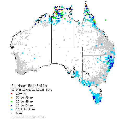
Some patchy falls confined to the NSW, Qld and NT coast and ranges in the last day or so. Click on the link for an updated map. http://www.bom.gov.au/australia/flood/?ref=ftr

Some patchy falls confined to the NSW, Qld and NT coast and ranges in the last day or so. Click on the link for an updated map. http://www.bom.gov.au/australia/flood/?ref=ftr

Weekly rain shows some fantastic falls across the tropics and parts of CQ desperately in need of rain. NSW has been on the skinnier end of falls in the last week.Australian 7-day rainfall map courtesy http://www.bom.gov.au/climate/maps/rainfall/?var…

Weekly rain shows some fantastic falls across the tropics and parts of CQ desperately in need of rain. NSW has been on the skinnier end of falls in the last week.

Australian 7-day rainfall map courtesy http://www.bom.gov.au/climate/maps/rainfall/?variable=rainfall&map=totals&period=week&region=nat&year=2020&month=12&day=17

Multi-week model analysis (8-28 days)

Multiweek models.jpg

In the coming weeks, all the action looks to be in the FN Qld tropics and the NW Australian coastline, the latter off the back of warming SSTs and a weak MJO approaching. With the SAM dipping back towards neutral, there is nothing to suggest decent rainfall totals until at least the first week in February for most areas. Temperatures should continue to remain mild consistent with a La Niña summer. Overall, the climate is giving us little direction, while we wait in some sort of holding pattern for something to change.

horse-race-silhouette-3.png

Model commentary: The IRI multi-week model is back to its cautious best, showing rain for some areas in the tropics and a neutral flavour throughout until 12 Feb. The JMA has done a u-turn on rain for the end of Jan, with a more general rain event predicted for eastern Australia 1st half of Feb. The 16-day NCEP model is only showing patchy rain events and storm rain for most areas. The BOM ACCESS-S model has come off its high from wet-wet-wet to favour northern areas over the coming weeks and drier conditions for NSW and inland Qld areas. Keep an eye on the Meteologix 10 day Forecast XL for a full summary of all ‘weather models’ as events draw closer for your area: https://meteologix.com/au

Monitoring the SAM

The SAM is set to dip into negative and then recover the around neutral levels. A stronger positive surge of the SAM would certainly boost confidence for rainfall prospects in areas such as the Darling Downs and Liverpool Plains this time of year. It looks unlikely the SAM will impact our climate in the coming weeks.

Antarctic Oscillation or SAM values (15 Jan)

Recent research by Hendon et al, (2014) at the Centre for Australian Weather and Climate Research found the Southern Annular Mode to be the leading mode of circulation variability through parts of inland eastern Australia where cotton is grown; particularly in the spring planting period.
 
A positive SAM has been proven to increase moisture supply into fronts and troughs forming in eastern Australia. The chart provided by Climate Prediction Center (US) shows the most recent observations of the SAM or (AAO). 

A negative SAM traditionally leads to a dry westerly circulation pattern through eastern Australian cropping areas.
 
BOM researchers Lim and Hendon (2013) found the SAM has the strongest connection with El-Niño Southern Oscillation in October and November – whereby the SAM is influenced most by El Niño or La Niña conditions.

Growers and advisors are encouraged to monitor the phases of the SAM together with seasonal forecasting, multi-week and short term weather models during planting. A short cartoon explaining the SAM can be found HERE

Monitoring the MJO this summer

Much of our moisture originates from the tropics this time of year. The chart below shows the MJO currently in Phase 3 out in the Indian Ocean. A weak pulse may affect Australia (Phases 5-6) at the end of January. rather than the MJO, the latest NCEP report states “stationary La Niña signal continuing to dominate the overall global tropical convective field”

The Madden – Julian Oscillation (MJO) is a tropical disturbance that moves eastward around the global tropics every 30-60 days and has proven to influence rainfall and temperature conditions. The strength of the MJO may increase or decrease as it progresses eastwards, affecting the level of convection and influence on both precipitation and temperature. The diagram below is used by scientists to track the path of the MJO showing predicted dates through various phases (see last weeks edition for MJO explainer). This illustrates the MJO currently inactive inside the circle, then increasing in strength through week 2 in January as it reaches the maritime continent. Not all models are aligned and some show no signal for the MJO whatsoever. A short YouTube cartoon explaining the MJO can be found here

Global tropical hazards

(from U.S Climate Prediction Center)

NCEP TC watch is not overly excited about cyclones around Australia in the next fortnight, which is not what was expected at the peak of the La Niña. All the activity is currently further west in the Indian Ocean.

Rather, the approaching weak MJO signal looks to be bringing rain right across the tropics for the end of January. The next week will be more interesting.

Holeman Aspect Wi-Fi weather station review

Holeman.png

Tried & tested

By Richard Beattie, Moree

A quick trip into Bunnings and XX purchase uncovered a very useful product

xx

Pro’s & Cons

  • xx

In his Parramatta shorts, Matt feeding hay out on his familys beef cattle farm as a 10-year-old during the 1982-83 El Nino.

In his Parramatta shorts, Matt feeding hay out on his familys beef cattle farm as a 10-year-old during the 1982-83 El Nino.

The RMM index or “spider diagram” is used by climate scientists around the globe to track the location and strength of the MJO (image courtesy BOM).

The RMM index or “spider diagram” is used by climate scientists around the globe to track the location and strength of the MJO (image courtesy BOM).

XXX

HoLman

HoLman


Had experience, with good, bad or ugly weather stations???

Email us at: farmerforecast@agecon.com.au

Monitoring heat waves over Christmas

With the exception of Kununurra, W.A and the Riverina in southern NSW, all other areas will experience mild temperatures through until the middle of next week.

Heatwave forecast starting Saturday 9 January through to Wednesday 13 January 2020

heatwve.jpg

About heat waves

Heatwaves are calculated using the forecast maximum and minimum temperatures over the next three days, comparing this to actual temperatures over the previous thirty days, and then comparing these same three days to the 'normal' temperatures expected for that particular location. Using this calculation takes into account people's ability to adapt to the heat. For example, the same high temperature will be felt differently by residents in Moree compared to those in Orange, who are not used to the higher range of temperatures experienced in Moree. The full forecast can be accessed here: http://www.bom.gov.au/australia/heatwave/

9-day ECMWF rainfall outlook

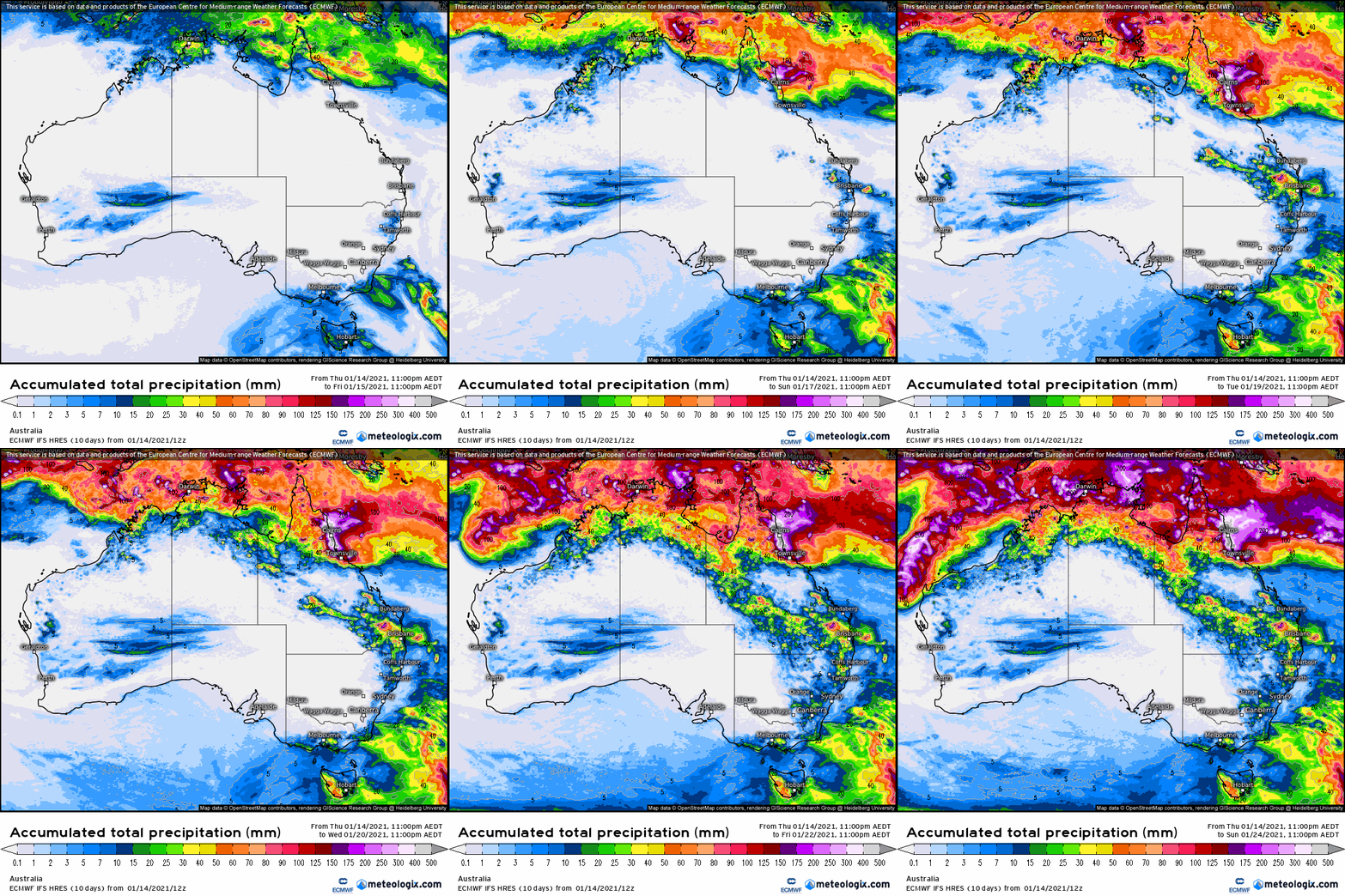
The European ECMWF 9-day model shows rainfall in the parched Fitzroy Valley and further north in the tropics in the forecast period with storms also occurring through the northern NSW ranges.

This mornings updated multi-week models show rain for western NSW at the end of January and continued storm activity in the tropics. Broad inland areas of Qld and the Murray Darling Basin may see a 2-3 week period of reasonable fine weather (after this 9 day period), as we wait for the MJO to return to the Australian region.

Access courtesy https://meteologix.com/au

modez_20210107_2200_animation.gif

Climate in-brief

  • Moisture levels and cloudiness remains high to Australia’s north with the Northern Coral Sea very warm, albeit with MJO forecast to appear in the Indian Ocean, away from Australia in the coming week.

  • Very little in the way of cyclone activity expected in the coming fortnight, as waters cool to Australia’s north

  • The Southern Annular Mode is maintaining its good form in moderately positive (wet) phase and predicted to remain so, - assisting moisture flow through NSW and S Qld areas.

  • Multi-week models showing split fortunes for tropics and mid-latitudes, with some caution for large areas of Qld through January. On the other hand, consensus shows continued moisture for much if NSW and SE Qld over the coming 4 weeks.

  • Temperatures to remain around normal or cooler throughout January, consistent with increased cloud cover and influence of the current La Nina.

The chart above shows higher-than-normal air pressure in Southern Australia for the last 30-days and lower air pressure to the NW.

The chart above shows higher-than-normal air pressure in Southern Australia for the last 30-days and lower air pressure to the NW.

Australian daily and weekly rainfall observations

Some handy falls confined to the coast and ranges in the last day or so. Click on the link for an updated map. http://www.bom.gov.au/australia/flood/?ref=ftr

Some handy falls confined to the coast and ranges in the last day or so. Click on the link for an updated map. http://www.bom.gov.au/australia/flood/?ref=ftr

Weekly rain shows some fantastic falls across the tropics, with the belated arrival of the much-touted 2020 la nina! the NSW north coast and ranges of NSW still in the storm track over xmas, along with the norther Territory and Western Australia.Aus…

Weekly rain shows some fantastic falls across the tropics, with the belated arrival of the much-touted 2020 la nina! the NSW north coast and ranges of NSW still in the storm track over xmas, along with the norther Territory and Western Australia.

Australian 7-day rainfall map courtesy http://www.bom.gov.au/climate/maps/rainfall/?variable=rainfall&map=totals&period=week&region=nat&year=2020&month=12&day=17