Multi-week model analysis (8-28 days)
/Some spectacular colours coming through on the weather models to start 2021. However, when we move further into January the models seem to be picking up on cooling waters in the Coral Sea and again in Australia’s north. After January week 1, some caution for Qld areas, with the exception of FN Qld that cool and dry weather might persist through January. On the other hand, the activity seems to favour NSW areas, with cool, moist air continuing to feed into that state for much of the next 1-4 week period.
Model commentary: The IRI is certainly more optimistic for NSW in January and bearish for Kununurra and the NT Big Rivers through the next 4 weeks. The JMA is again aligned for rain across NSW and a much weaker rainfall signal for a general event in the 2nd half of January which is not overly convincing. Some small to moderate totals showing on the 16-day NCEP models, although this favour the ranges and FN Qld tropics. The BOM ACCESS-S model is picking up where it left off in 2020, with rose coloured glasses for all areas in January. I’m not sure why I bother with it, but those results need to be taken with a grain (or tablespoon) of salt. Keep an eye on the Meteologix 10 day Forecast XL for a full summary of all ‘weather models’ as events draw closer for your area: https://meteologix.com/au
Monitoring the SAM
/The SAM continues in positive phase, which is great news for NSW and S Qld areas. The forecast (not displayed) shows the SAM being quite stable in a moderately positive zone. This will allow moisture flow into key eastern Australian agricultural areas. A strong positive surge of the SAM would certainly boost confidence for rainfall prospects in areas such as the Darling Downs and Liverpool Plains this time of year.
Antarctic Oscillation or SAM values (31 Dec)
Recent research by Hendon et al, (2014) at the Centre for Australian Weather and Climate Research found the Southern Annular Mode to be the leading mode of circulation variability through parts of inland eastern Australia where cotton is grown; particularly in the spring planting period.
A positive SAM has been proven to increase moisture supply into fronts and troughs forming in eastern Australia. The chart provided by Climate Prediction Center (US) shows the most recent observations of the SAM or (AAO).
A negative SAM traditionally leads to a dry westerly circulation pattern through eastern Australian cropping areas.
BOM researchers Lim and Hendon (2013) found the SAM has the strongest connection with El-Niño Southern Oscillation in October and November – whereby the SAM is influenced most by El Niño or La Niña conditions.
Growers and advisors are encouraged to monitor the phases of the SAM together with seasonal forecasting, multi-week and short term weather models during planting. A short cartoon explaining the SAM can be found HERE.
Monitoring the MJO this summer
/Much of our moisture originates from the tropics this time of year. The chart below shows a pulse of moist air in Phase 5 over Australian longitudes (green line) around 10-14 January. Tracking this tropical moisture can help us understand when rain-bearing systems or heatwaves are more likely.
The Madden – Julian Oscillation (MJO) is a tropical disturbance that moves eastward around the global tropics every 30-60 days and has proven to influence rainfall and temperature conditions. The strength of the MJO may increase or decrease as it progresses eastwards, affecting the level of convection and influence on both precipitation and temperature. The diagram below is used by scientists to track the path of the MJO showing predicted dates through various phases (see last weeks edition for MJO explainer). This illustrates the MJO currently inactive inside the circle, then increasing in strength through week 2 in January as it reaches the maritime continent. Not all models are aligned and some show no signal for the MJO whatsoever. A short YouTube cartoon explaining the MJO can be found here
Global tropical hazards
/(from U.S Climate Prediction Center)
NCEP TC watch is not overly excited about cyclones in the next fortnight.
Consistent with NCEP, Jason Nicholls (@jnmet) at ACCU weather shows potential cyclone development occurring throughout January is low, with a tropical low more likely with increased cloudiness occurring through the whole month (RHS bottom chart).
9-day ECMWF rainfall outlook
/The European ECMWF 9-day model shows rainfall deepening into central NSW and NE Queensland. Tropical moisture continuing for NT agricultural areas also.
A wet NSW and S Qld forecast is showing a classic positive (wet) phase - SAM signature, with abundant moisture flowing into those areas. A very warm northern Coral Sea is feeding moisture into the northern Qld tropics.
Access courtesy https://meteologix.com/au
Analysis - MJO: what is it and why do we watch it?
/The Madden-Julian Oscillation (MJO) is the major fluctuation in tropical weather on weekly to monthly timescales. The MJO can be characterised as an eastward moving 'pulse' of cloud and rainfall near the equator that typically recurs every 30 to 60 days.
MJO Explainer
Predicting the MJO and where is it now?
Due to its slowly evolving nature, accurate prediction of the MJO is fundamentally related to scientists ability to monitor the feature and to assess its relative position and strength. Dynamical models generally do not predict the MJO well, partly because of the inherent difficulties that still remain regarding the correct mathematical treatment of tropical convective (rainfall) processes. Meteorologists use a variety of data and analysis techniques to monitor, study, and predict the formation and evolution of the MJO.
In the chart below;
The black line is observations with dates (where it is now is largest black dot #21)
The yellow lines are potential modelled outcomes (bracketed by shading)
The green line is the median prediction (where to next)
The phase is its location: Australia generally 5-6
The strength is indicated by where it is plotted: inside the circle = weak. Outside the circle = stronger. The closer to the outside, the stronger the pulse.
So what?
Dynamical models favour little to no MJO activity during Week-1 (22-29 Dec) but suggest potential renewed MJO activity over the Indian Ocean during Week-2 (30 Dec-6 Jan).
Given the current weak signal, the MJO is unlikely to substantially influence the tropical convective pattern or subsequent extratropical response. The ongoing La Niña remains the primary tropical convective driver (see the latest NCEP conditions report).
The weaker MJO may reduce tropical moisture but it has a silver lining - a strong MJO in phases 8-1 can bring on heat waves which we can do without!
Monitoring heat waves over Christmas
/Most areas will experience mild temperatures over the Christmas long weekend. A low intensity heatwave condition is forecast North and South of Cairns, with easing heat around Perth and persisting heat in Western Australia’s Central West.
Heatwave forecast starting Thursday 24 December through to Tuesday 29 December 2020
About heat waves
Heatwaves are calculated using the forecast maximum and minimum temperatures over the next three days, comparing this to actual temperatures over the previous thirty days, and then comparing these same three days to the 'normal' temperatures expected for that particular location. Using this calculation takes into account people's ability to adapt to the heat. For example, the same high temperature will be felt differently by residents in Moree compared to those in Orange, who are not used to the higher range of temperatures experienced in Moree. The full forecast can be accessed here: http://www.bom.gov.au/australia/heatwave/
9-day ECMWF rainfall outlook
/The European ECMWF 9-day model shows rainfall deepening into desert areas of Western Australia with a weak pulse of the MJO now in Phase 5 in Australia’s north-west. The rainfall situation is set to become more interesting in the next fortnight as the MJO is anticipated to strengthen as it propagates further eastward towards the Pacific Ocean.
Refreshed multi-week models are consistently showing cool, wet conditions for NSW and Qld areas right through until 3 January 2021, so the La Niña might be settling in after all.
More details in next Fridays fortnightly analysis.
Access courtesy https://meteologix.com/au
Climate in-brief
/Moisture levels and tropical divergence remains high to Australia’s north, albeit with MJO predictions offering little in terms of strength and its next move.
The Southern Annular Mode is weakly-moderately positive and predicted to remain so, - assisting moisture flow through NSW and S Qld areas.
Multi-week models showing some signs of low-air pressure and moisture continuing into the second week of January. Shorter-term guidance is showing only sporadic and smaller totals throughout the forecast area - staying in touch with information when it comes to hand will be critical in the coming days
Temperatures to remain around normal or cooler through until mid-January, consistent with the presence of the MJO to Australia’s north
Australian weekly rainfall and relative landscape water balance
Multi-week model analysis (8-28 days)
/The broad-scale pattern has finally aligned to some degree, with cooler moist air favoured to camp in the Australian region for possibly the next three to four weeks. The guidance suggests impacts and moisture receding into January, although this will largely be determined by the next move of the MJO - which is currently not acting to script. One concern for regional Qld areas is the 7-day SST anomaly showing a cooling of waters in the Coral Sea again, reducing moisture availability - at odds with the La Niña signal.
Model commentary: scrolling through the various weekly forecast intervals, the peak opportunity for rainfall appears to be through until around the 28 December. The JMA model is bullish wet for a month, albeit tapering off in January. The IRI model seems to be picking up on the cooling Coral Sea and is less enthusiastic about January. ACCESS-S continues unabated for a wet finish to December, so nothing has changed with it. The 16-day NCEP has small sporadic falls showing in the majority of areas, much more cautious even than the 9-day ECMWF loop. Keep an eye on the Meteologix 10 day Forecast XL for a full summary of all ‘weather models’ as events draw closer for your area: https://meteologix.com/au
Monitoring the SAM
/The SAM continues in positive phase, which is great news for NSW and Qld areas. The forecast shows the SAM being quite stable in a moderately positive zone. This will allow moisture flow into key eastern Australian agricultural areas. A strong positive surge of the SAM would certainly boost confidence for rainfall prospects in areas such as the Darling Downs and Liverpool Plains this time of year.
Antarctic Oscillation or SAM values (18 Dec)
Recent research by Hendon et al, (2014) at the Centre for Australian Weather and Climate Research found the Southern Annular Mode to be the leading mode of circulation variability through parts of inland eastern Australia where cotton is grown; particularly in the spring planting period.
A positive SAM has been proven to increase moisture supply into fronts and troughs forming in eastern Australia. The chart provided by Climate Prediction Center (US) shows the most recent observations of the SAM or (AAO).
A negative SAM traditionally leads to a dry westerly circulation pattern through eastern Australian cropping areas.
BOM researchers Lim and Hendon (2013) found the SAM has the strongest connection with El-Niño Southern Oscillation in October and November – whereby the SAM is influenced most by El Niño or La Niña conditions.
Growers and advisors are encouraged to monitor the phases of the SAM together with seasonal forecasting, multi-week and short term weather models during planting. A short cartoon explaining the SAM can be found HERE.
Tracking atmospheric water vapour (Sat-Tue)
/The prediction for water vapour levels shows a concentration over northern NSW/S Qld and a large area in Australias NW, consistent with bullish rainfall prospects for those areas.
The water vapor content of the atmosphere is of critical importance to nearly every facet of atmospheric science. Observing the processes that determine the water vapor content of the atmosphere is, therefore, of fundamental importance. As the earth’s surface is the source of most atmospheric water vapor, observations of vertical turbulent transport of water vapor in the planetary boundary layer have been the subject of many research projects. Evapotranspiration can vary significantly across the earth’s surface due, for example, to variability in insolation, vegetation cover, soil properties, and precipitation. Area-averaged water vapor flux measurements are necessary to get a large-scale view of surface–atmosphere interactions.
The Extreme Forecasting Index (EFI) is an integral measure of the difference between the ensemble forecast (ENS) distribution and the model climate (M-climate) distribution. This allows the abnormality of the forecast weather situation to be assessed without defining specific (space- and time-dependant) thresholds. The EFI takes values from -1 to +1. If all the ensemble members forecast values above the M-climate maximum, EFI = +1; if they all forecast values below the M-climate minimum, EFI = -1. Experience suggests that EFI magnitudes of 0.5 - 0.8 (irrespective of sign) can be generally regarded as signifying that "unusual" weather is likely whilst magnitudes above 0.8 usually signify that "very unusual" weather is likely. Although larger EFI values indicate that an extreme event is more likely, the values do not represent probabilities as such.
Monitoring the MJO and tropical moisture this summer
/Much of our moisture originates from the tropics this time of year. The LHS chart shows tropical moisture (rising air at high altitude) over Australian longitudes (green shading). Similarly, RHS charts for the last 2 weeks, with low air pressure off eastern and northern Australia. Tracking this tropical moisture can help understand when rain-bearing systems are more likely.
The CPC (US) reports the Madden-Julian Oscillation (MJO) being “better organised” in Phase 5 this week (Australian region). The dynamical model spread for the next move of the MJO remains high, as ensemble means favour a decline of the intraseasonal signal over the Maritime Continent and western Pacific likely due to destructive interference with the ongoing La Niña. This limits forecast confidence on the predicted evolution and strength of the MJO into late December.
For a basic MJO explainer and why we need to watch the MJO, see the following animation here: https://www.youtube.com/watch?v=SwoB-2nSnJ0
Global tropical hazards
/(from U.S Climate Prediction Center)
Some action in the tropics at last! The noticeable features in the chart below show a potential cyclone development in the western Timor Sea and above normal rainfall for the Qld gulf and NE NSW next week (top chart).
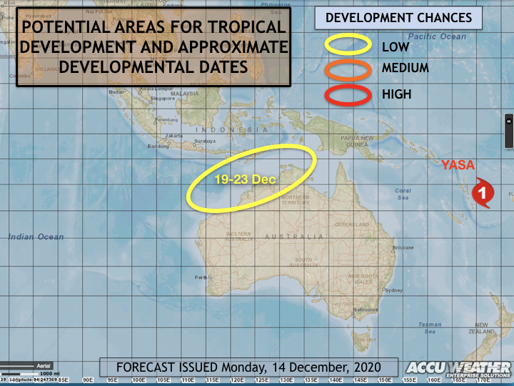
Jason Nicholls (@jnmet) at ACCU weather shows a low potential cyclone development occurring 19-23 December in Australia’s north-west (bottom chart).
9-day ECMWF rainfall outlook
/Fresh today, the European ECMWF 9-day model is bullish on rainfall for large tracts of eastern and northern Australia. A weak MJO is camped to the north of Australia and the waters in the north-west are very warm. The synoptic pattern shows low air pressure deepening over western and central Australia, consistent with the rainfall outlook.
The tropics have finally come to life on a decent scale. While this ECMWF model is bullish, it is prudent to survey other global models for refining weather-dependent decisions over the coming week.
Visit meteologix.com/au and navigate your way the Model XL forecast for your location.
Access courtesy https://meteologix.com/au
Farmer climate focus - John Hamparsum
/Location snapshot
Catchment: Upper Namoi Valley, NSW
Altitude: 300 m
Enterprise: Winter cropping: Durum, bread-wheat and canola
Summer cropping: Cotton and sorghum
Rainfall: Wet season (Oct-Mar): 61% rainfall
Cool-season (Apr-Sep): 39% rainfall
Seasonal rainfall climate drivers:
El Nino-Modoki (EMI) is the key climate driver, however, little connection exists post-January to May.
What are your ‘go-to’ sources of climate/weather information? Basically the internet. I’ve got pages of bookmarks of weather sources that I go to. Predominantly for the short-term, ten day kind of stuff, I use Meteorlogixs because of the ability to look at the eight or so different models in there. That gives you an idea of both temperature forecasts and rain forecasts between the models. The Bureau of Meteorology Land and Water is also another one I’ll look at. They both go through various stages of accuracy. The European model, the ECMWF, lately seems to be the most accurate and windy.com is also a very good website. Long-term, I used to read the Bureau forecasts but the last four summers they’ve got every one of them wrong so my faith in that has gone out the window. I mean, they have forecast a wet summer for the last four years and we’ve had record lows. Even this November was a record low month when they were forecasting above average rainfalls. I guess my faith in the BOM is pretty low at the moment, they are going to have to do a lot of work to get their credibility back up to an acceptable level.
How do you consider climate in your farm management? Climate is one of the main factors impacting a farming business. I mean, a farm is a factory without a roof on it. Climate has a major impact, whether it be heat waves, cold spells, dry spells, wet, windy, all of those have an impact on the productivity of your farm. Irrigation does tend to insulate you a little bit, but we, as most irrigators in the northern valleys know, in the last three years we have had no water. I am a member of the Farmers for Climate Action group and I am quite active in that because I believe that our climate is being impacted by climate change and I think that we need to be more proactive in that space, both on individual levels and as a nation and as a planet because climate is basically what will provide food and fibre for generations to come and it’s going to determine the success or failure of being able to supply that. It’s by looking at the long term climate drivers that you make decisions on how you’re going to farm, also with our crop configuration. We use it to make decisions about how much single-skip cotton we will plant versus solid plant irrigated country we will plant. So, we will make a decision asking are we going to cover ourselves by using single-skip which doesn’t use as much water and can handle water stress better and if it’s looking like we are going into a longer dry period we might increase our percentage of single-skip from 25 percent to 35 percent just to hedge our bets.
Can you share a climate success (or failure) story with us? Going back, I remember in 1992 the forecast, from talking to Roger Stone at the time, was that we were going in to a dry pattern with an el Nino and my father and I had the opportunity to put down another irrigation bore and we thought ‘let’s go ahead and do this.’ And it paid off because 1992 right through to ‘96 was incredibly dry and having that extra bore made the big difference to our yields.
How did your winter crops pan out? The sad part about it was that we had very good rain at the early part of establishment and the crop set itself up to be very large, sort of record breaking yield type structure to the plant and then it just stopped raining and we just were not prepared. Even though we had a full storage of water - well we irrigated one field and worked out how much water it was using and decided not to keep going because our confidence we were going to have a wet summer was not strong. So, we decided not to irrigate the rest of the wheat because we might need it for our summer crop and then the wheat crop hit the wall, moisture wise. We didn’t have a completely full profile coming out of the drought, even though we’d had some good rains we probably only had an 85, 90 percent profile. So, when that dry September hit it really capped out the yield in the winter crop.
How is the climate considered in your future planning? My membership to the Farmers for Climate Action group does play a major role but we are only individuals, we can’t influence how whole nations like China and Europe behave, but we can point out to our own government that we need to be taking actions against climate change. Hopefully this, not so much for me but for my children and their children, that will have a positive impact. Looking at some of the modelling I see that the extremes are going to be a lot more amplified. and for us, living on a flood plain, that could mean that the floods could be a lot worse and the dry times could be a lot worse and the strength of the storms and the voracity of them. The way I see it is, like any chemical experiment, the more heat you put in, the more wild the reaction is.
As an early subscriber, what do you value most from AgEcon’s services? I value the breadth of research that AgEcon is providing and interpreting for us. I really feel like I get a far more knowledgeable interpretation of all the models. I find it really useful and a powerful tool to be able to read those reports and listen to podcasts and make heads and tails of what’s happening rather than looking at the trees and seeing if there’s new shoots on them - which I also do.
Have a farming climate story to share? Please contact us.
Analysis - Sea Surface Temperature Distributions 2010 v 2020 La Niña's
/December 2010 Sea Surface Temperatures and rainfall deciles
December 2020 Sea Surface Temperatures and rainfall outlook (21 Dec 2020 - 3 Jan 2021)
So what?
The La Niña signature can be clearly seen in both images, with cool water extending into the western Pacific Ocean. Models are anticipating the Coral Sea to warm and deliver rainfall to eastern Qld areas (although the latest 7-day change maps on tropicaltidbits.com would suggest otherwise). The waters around the Maritime Continent are not near as warm as 2010. The next research article suggests that we need these waters, and those to the east of Australia to be much warmer to supply rainfall events this summer - this warming may well happen in the next month or so.
Latest research - tracing the origins of moisture for precipitation
/A team of Australian climate researchers recently investigated the origin of moisture for regional precipitation and the relative importance of local versus remote processes. Where does our moisture leading to rain come from?
Knowing the long-term average regional source of moisture provides insight into the drivers of precipitation during anomalously dry or wet periods. In the case of drought, for example, identifying the long-term average source regions can help reveal whether the low precipitation was due to a reduction in source evaporation, anomalous atmospheric circulation or a lack of local precipitation generating mechanisms.
Key findings of the study;
In summer, moisture for the Australian continent generally was primarily sourced from Australia’s Maritime Continent (waters around Philippines/Indonesia/Papua New Guinea)
Summer precipitation in the Murray Darling Basin (MBD) was primarily sourced from the Tasman Sea, Southern Ocean and land within the basin itself.
The MBD recycled more moisture from land sources for precipitation than any other eastern basin, with a maximum of 9.2% across the year.
The Australian continent receives a minimum of 77% of moisture from marine sources in summer and a maximum of 89% in winter, with the remainder recycled from land sources.
North-West Cloud Bands relating to the Indian Ocean Dipole interact with moisture from condensed moist air from the Tasman Sea to deliver precipitation to the MDB during spring.
What does all of this mean?
Coming into summer season, the distribution of warm waters around our perimeter does impact rainfall, although atmospheric processes involved to deliver that moisture is a whole other story!
We hope the land-sea interaction is captured in General Circulation Models, although it’s worthy of periodical monitoring the Sea Surface Temperatures in those areas identified by researchers and compare with other similar years.
Paper: Holgate, C.M., Evans, J.P., Van Dijk, A.I.J.M., Pitman, A.J. and Di Virgilio G. Australian Precipitation Recycling and Evaporative Source Regions (2020) Journal of Climate. https://doi.org/10.1175/JCLI-D-19-0926.s1
Monitoring heat waves this summer
/About heat waves
Heatwaves are calculated using the forecast maximum and minimum temperatures over the next three days, comparing this to actual temperatures over the previous thirty days, and then comparing these same three days to the 'normal' temperatures expected for that particular location. Using this calculation takes into account people's ability to adapt to the heat. For example, the same high temperature will be felt differently by residents in Moree compared to those in Orange, who are not used to the higher range of temperatures experienced in Moree. The full forecast can be accessed here: http://www.bom.gov.au/australia/heatwave/
Nothing to speak of in terms of extreme heat in the coming week.