2021 Autumn seasonal outlook

Bullish. That sums up the next three months for most areas. Warm waters from the La Nina appear slow to decay. Waters that have been cool in the Coral Sea are warming up. The strongest signals seem to be through central-eastern Australia, with cool/average temps across the continent.

The combined 5x North American models (bottom RHS) seem to be anticipating moisture from NW Australia to stream down into SE Aust. Whereas the BOM (top left) and combined 5x European model (top right) is favouring Queensland and NSW areas in the coming months.

autumn 2.jpg

Global tropical hazards

(from U.S Climate Prediction Center)

NCEP TC watch is not overly excited about cyclones around Australia in the next fortnight, which is not what was expected at the peak of the La Niña. All the activity is currently further west in the Indian Ocean.

Rather, the approaching weak MJO signal looks to be bringing rain right across the tropics for the end of January. The next week will be more interesting.

Global tropical hazards

(from U.S Climate Prediction Center)

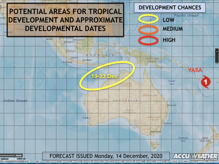
Some action in the tropics at last! The noticeable features in the chart below show a potential cyclone development in the western Timor Sea and above normal rainfall for the Qld gulf and NE NSW next week (top chart).

Jason Nicholls (@jnmet) at ACCU weather shows a low potential cyclone development occurring 19-23 December in Australia’s north-west (bottom chart).

jnmet cyclone.png

Global tropical hazards

(from U.S Climate Prediction Center)

Some action in the tropics at last! The noticeable features in the chart below show a potential cyclone development in the western Timor Sea and above normal rainfall for the Qld gulf and tropical coast next week (bottom chart).

Jason Nicholls (@jnmet) at ACCU weather reports this morning, the potential cyclone development occurring 7-12 December in Australia’s north-west.

accu weather TCs.png

Global tropical hazards

(from U.S Climate Prediction Center)

The noticeable features in the chart below show the green colours in the Indian Ocean where the MJO currently resides, not really progressing eastwards towards Australia. When the tropical moisture in the Pacific begins to move Easterly (towards Australia), this will increase the probability of our cyclonic activity and rainfall.

Cyclone season 2020-21: almost double last years cyclones anticipated

With the Australian cyclone season less than one month away, AccuWeather meteorologists say Australia may have not only a more active tropical season than the last but also one with more storms making landfall on the nation's shores.

During the 2019-2020 hurricane season, the Australian basin produced nine cyclones, slightly below the average of 11, with the first cyclone developing in a late start to the season. Cyclone Blake, which formed off of northwestern Australia on Jan. 4, 2020, came two months after the official start of the season, which runs from November to April.

The first cyclone of this season is expected to form before the end of December, kicking off a potentially more active season for the basin.

For the full article, click here: https://www.accuweather.com/en/hurricane/australian-tropical-season-to-pull-a-topsy-turvy-from-last-year/823466

Global tropical hazards 25/9/20

(from U.S Climate Prediction Center)

 A typically stable period for our region, there is no tropical hazards forecast. The northern Australian tropics are subject to a drier air mass moving through (a Rossby wave), although there is activity along the equator. Cyclones may start to appear off the west coast over the coming months, and gradually move eastward into next year.