9-day ECMWF rainfall outlook

The European ECMWF 9-day model shows rainfall in the parched Fitzroy Valley and further north in the tropics in the forecast period with storms also occurring through the northern NSW ranges.

This mornings updated multi-week models show rain for western NSW at the end of January and continued storm activity in the tropics. Broad inland areas of Qld and the Murray Darling Basin may see a 2-3 week period of reasonable fine weather (after this 9 day period), as we wait for the MJO to return to the Australian region.

Access courtesy https://meteologix.com/au

modez_20210107_2200_animation.gif

Monitoring the MJO this summer

Much of our moisture originates from the tropics this time of year. The chart below shows a pulse of moist air in Phase 5 over Australian longitudes (green line) around 10-14 January. Tracking this tropical moisture can help us understand when rain-bearing systems or heatwaves are more likely.

The Madden – Julian Oscillation (MJO) is a tropical disturbance that moves eastward around the global tropics every 30-60 days and has proven to influence rainfall and temperature conditions. The strength of the MJO may increase or decrease as it progresses eastwards, affecting the level of convection and influence on both precipitation and temperature. The diagram below is used by scientists to track the path of the MJO showing predicted dates through various phases (see last weeks edition for MJO explainer). This illustrates the MJO currently inactive inside the circle, then increasing in strength through week 2 in January as it reaches the maritime continent. Not all models are aligned and some show no signal for the MJO whatsoever. A short YouTube cartoon explaining the MJO can be found here

9-day ECMWF rainfall outlook

The European ECMWF 9-day model shows rainfall deepening into central NSW and NE Queensland. Tropical moisture continuing for NT agricultural areas also.

A wet NSW and S Qld forecast is showing a classic positive (wet) phase - SAM signature, with abundant moisture flowing into those areas. A very warm northern Coral Sea is feeding moisture into the northern Qld tropics.

Access courtesy https://meteologix.com/au

modez_20210101_2100_animation.gif

9-day ECMWF rainfall outlook

The European ECMWF 9-day model shows rainfall deepening into desert areas of Western Australia with a weak pulse of the MJO now in Phase 5 in Australia’s north-west. The rainfall situation is set to become more interesting in the next fortnight as the MJO is anticipated to strengthen as it propagates further eastward towards the Pacific Ocean.

Refreshed multi-week models are consistently showing cool, wet conditions for NSW and Qld areas right through until 3 January 2021, so the La Niña might be settling in after all.

More details in next Fridays fortnightly analysis.

Access courtesy https://meteologix.com/au

modez_20201224_0000_animation.gif

Tracking atmospheric water vapour (Sat-Tue)

The prediction for water vapour levels shows a concentration over northern NSW/S Qld and a large area in Australias NW, consistent with bullish rainfall prospects for those areas.

The water vapor content of the atmosphere is of critical importance to nearly every facet of atmospheric science. Observing the processes that determine the water vapor content of the atmosphere is, therefore, of fundamental importance. As the earth’s surface is the source of most atmospheric water vapor, observations of vertical turbulent transport of water vapor in the planetary boundary layer have been the subject of many research projects. Evapotranspiration can vary significantly across the earth’s surface due, for example, to variability in insolation, vegetation cover, soil properties, and precipitation. Area-averaged water vapor flux measurements are necessary to get a large-scale view of surface–atmosphere interactions. 

The Extreme Forecasting Index (EFI) is an integral measure of the difference between the ensemble forecast (ENS) distribution and the model climate (M-climate) distribution. This allows the abnormality of the forecast weather situation to be assessed without defining specific (space- and time-dependant) thresholds. The EFI takes values from -1 to +1. If all the ensemble members forecast values above the M-climate maximum, EFI = +1; if they all forecast values below the M-climate minimum, EFI = -1. Experience suggests that EFI magnitudes of 0.5 - 0.8 (irrespective of sign) can be generally regarded as signifying that "unusual" weather is likely whilst magnitudes above 0.8 usually signify that "very unusual" weather is likely. Although larger EFI values indicate that an extreme event is more likely, the values do not represent probabilities as such. 

Monitoring the MJO and tropical moisture this summer

Much of our moisture originates from the tropics this time of year. The LHS chart shows tropical moisture (rising air at high altitude) over Australian longitudes (green shading). Similarly, RHS charts for the last 2 weeks, with low air pressure off eastern and northern Australia. Tracking this tropical moisture can help understand when rain-bearing systems are more likely.

The CPC (US) reports the Madden-Julian Oscillation (MJO) being “better organised” in Phase 5 this week (Australian region). The dynamical model spread for the next move of the MJO remains high, as ensemble means favour a decline of the intraseasonal signal over the Maritime Continent and western Pacific likely due to destructive interference with the ongoing La Niña. This limits forecast confidence on the predicted evolution and strength of the MJO into late December.

For a basic MJO explainer and why we need to watch the MJO, see the following animation here: https://www.youtube.com/watch?v=SwoB-2nSnJ0

9-day ECMWF rainfall outlook

Fresh today, the European ECMWF 9-day model is bullish on rainfall for large tracts of eastern and northern Australia. A weak MJO is camped to the north of Australia and the waters in the north-west are very warm. The synoptic pattern shows low air pressure deepening over western and central Australia, consistent with the rainfall outlook.

The tropics have finally come to life on a decent scale. While this ECMWF model is bullish, it is prudent to survey other global models for refining weather-dependent decisions over the coming week.

Visit meteologix.com/au and navigate your way the Model XL forecast for your location.

Access courtesy https://meteologix.com/au

modez_20201217_2300_animation.gif

Monitoring heat waves this summer

About heat waves

Heatwaves are calculated using the forecast maximum and minimum temperatures over the next three days, comparing this to actual temperatures over the previous thirty days, and then comparing these same three days to the 'normal' temperatures expected for that particular location. Using this calculation takes into account people's ability to adapt to the heat. For example, the same high temperature will be felt differently by residents in Moree compared to those in Orange, who are not used to the higher range of temperatures experienced in Moree. The full forecast can be accessed here: http://www.bom.gov.au/australia/heatwave/

Nothing to speak of in terms of extreme heat in the coming week.

Heatwave forecast starting Monday 14 December through to Wednesday 16 December 2020

9-day ECMWF rainfall outlook

Fresh today, the European ECMWF 9-day model shows rainfall deepening into desert areas of Western Australia with a weak pulse of the MJO now in Phase 5 in Australia’s north-west. The rainfall situation is set to become more interesting in the next fortnight as the MJO is anticipated to strengthen as it propagates further eastward towards the Pacific Ocean.

Refreshed multi-week models are consistently showing cool, wet conditions for NSW and Qld areas right through until 3 January 2021, so the La Niña might be turning up after all.

More details in next Fridays fortnightly analysis.

Access courtesy https://meteologix.com/au

modez_20201210_2300_animation.gif

In case you missed it - Summer seasonal outlook Podcast

Last week, we congregated in the Narrabri Max FM community radio studios to record our take on what’s going on with the climate at the moment and the outlook for the next 3 months of summer.

To access the 11-minute recording, click here: 👉 https://player.whooshkaa.com/episode?id=765308

For those interested, the IPO poster (image below) mentioned in the podcast can be found here:

https://www.longpaddock.qld.gov.au/rainfall-poster/map-app/

Ad for LinkedIn and social.png

IPO.png

Chart of the Week - water vapour prediction (Sat-Tue)

The water vapor content of the atmosphere is of critical importance to nearly every facet of atmospheric science. Observing the processes that determine the water vapor content of the atmosphere is, therefore, of fundamental importance. As the earth’s surface is the source of most atmospheric water vapor, observations of vertical turbulent transport of water vapor in the planetary boundary layer have been the subject of many research projects. Evapotranspiration can vary significantly across the earth’s surface due, for example, to variability in insolation, vegetation cover, soil properties, and precipitation. Area-averaged water vapor flux measurements are necessary to get a large-scale view of surface–atmosphere interactions. 

The Extreme Forecasting Index (EFI) is an integral measure of the difference between the ensemble forecast (ENS) distribution and the model climate (M-climate) distribution. This allows the abnormality of the forecast weather situation to be assessed without defining specific (space- and time-dependant) thresholds. The EFI takes values from -1 to +1. If all the ensemble members forecast values above the M-climate maximum, EFI = +1; if they all forecast values below the M-climate minimum, EFI = -1. Experience suggests that EFI magnitudes of 0.5 - 0.8 (irrespective of sign) can be generally regarded as signifying that "unusual" weather is likely whilst magnitudes above 0.8 usually signify that "very unusual" weather is likely. Although larger EFI values indicate that an extreme event is more likely, the values do not represent probabilities as such. 

Let’s hope the high levels of atmospheric water vapour can flow through to precipitation in parched N NSW and S Qld areas (image courtesy ECMWF).

Summer seasonal outlook - Podcast out now!

Earlier this week, we congregated in the Narrabri Max FM community radio studios to record our take on what’s going on with the climate at the moment and the outlook for the next 3 months of summer.

To access the 11-minute recording, click here: 👉 https://player.whooshkaa.com/episode?id=765308

For those interested, the IPO poster (image below) mentioned in the podcast can be found here:

https://www.longpaddock.qld.gov.au/rainfall-poster/map-app/

Ad for LinkedIn and social.png

IPO.png

9-day ECMWF rainfall outlook

Fresh today, the European ECMWF 9-day model shows rainfall deepening into desert areas of Western Australia with the MJO approaching. Kununurra, Katherine and Gulf areas should see a break in the next week or so. Some moisture also filtering down the Qld coast and scattered areas of NSW inland and ranges. Date range: 3rd - 13th December.

Updated multi-week models are still bullish this morning for a general rain event December weeks 2-4, consistent with the last fortnight.

Access courtesy https://meteologix.com/au

modez_20201203_2100_animation.gif

9-day ECMWF rainfall outlook

Fresh today, the European ECMWF 9-day model shows rainfall for the next week mainly confined to Katherine, Kununurra, the parched northern NSW tablelands and a few handy falls further south at the end of the forecast loop. Date range: 26th November - 6th December.

Updated multi-week models are still bullish this morning for a general rain event December weeks 2-3, and a return to more normal temps for the remainder of the month. A full review next Friday.

Access courtesy https://meteologix.com/au

9 day ecmwf.gif

9-day ECMWF rainfall outlook

Fresh this morning, this European model shows rainfall for the next week mainly confined to Katherine, Kununurra and the parched NSW northern ranges. Some handy falls possible along the Great Dividing Range further south. Date range: 26th November - 6 December.

The remainder of December looks interesting. Air pressure at Darwin is now at 1005 hPa, which is well below average - exhibiting monsoon-like characteristics. The bug-bear at the moment is cooling sea temperatures around the Arafura and Coral Seas, not consistent with a La Niña like conditions. In turn, the MJO is losing steam when it comes from west-east and arrives in the Australian region. The latest multi-week models are still bullish for a general change and rain week 2-3 (coinciding with a weak MJO) of December and a return to average temps.

Access courtesy https://meteologix.com/au

9 day ecmwf.gif

Seasonal Model Survey

This is the last survey of seasonal models for the year, as accuracy is greatly reduced during the wet season. The general consensus throughout the global models is for wetter conditions although probabilities have been slightly reduced. The cooler waters north of Australia may be flowing through in the models to issue a more cautious approach to the Big Rivers and Kununurra areas. This La Niña has a few tricks left in it. One cannot assume broadscale and plentiful moisture for all.

Seasonal Model survey 23 October 2020

Seasonal Model survey 23 October 2020

Chart of the Week - water vapour approaching

The water vapor content of the atmosphere is of critical importance to nearly every facet of atmospheric science. Observing the processes that determine the water vapor content of the atmosphere is, therefore, of fundamental importance. As the earth’s surface is the source of most atmospheric water vapor, observations of vertical turbulent transport of water vapor in the planetary boundary layer have been the subject of many research projects. Evapotranspiration can vary significantly across the earth’s surface due, for example, to variability in insolation, vegetation cover, soil properties, and precipitation. Area-averaged water vapor flux measurements are necessary to get a large-scale view of surface–atmosphere interactions. 

The Extreme Forecasting Index (EFI) is an integral measure of the difference between the ensemble forecast (ENS) distribution and the model climate (M-climate) distribution. This allows the abnormality of the forecast weather situation to be assessed without defining specific (space- and time-dependant) thresholds. The EFI takes values from -1 to +1. If all the ensemble members forecast values above the M-climate maximum, EFI = +1; if they all forecast values below the M-climate minimum, EFI = -1. Experience suggests that EFI magnitudes of 0.5 - 0.8 (irrespective of sign) can be generally regarded as signifying that "unusual" weather is likely whilst magnitudes above 0.8 usually signify that "very unusual" weather is likely. Although larger EFI values indicate that an extreme event is more likely, the values do not represent probabilities as such. 

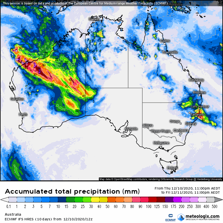
What does this mean? The prediction for excess water vapour and the presence of an “atmospheric river” will grace eastern Australia this weekend, and is classified as an unusual and extreme event, in areas shaded red (image courtesy ECMWF).